IMAGES TAKEN NEAR TO
Witton Gilbert, DURHAM, DH7 6QT
Introduction
This page details the photographs taken nearby to DH7 6QT by members of the Geograph project.
The Geograph project started in 2005 with the aim of publishing, organising and preserving representative images for every square kilometre of Great Britain, Ireland and the Isle of Man.

There are currently over 7.5m images from over14,400 individuals and you can help contribute to the project by visiting https://www.geograph.org.uk
Image Map
Images are licensed for reuse under creativecommons.org/licenses/by-sa/2.0
Notes
- Clicking on the map will re-center to the selected point.
- The higher the marker number, the further away the image location is from the centre of the postcode.
Image Listing (12 Images Found)
Images are licensed for reuse under creativecommons.org/licenses/by-sa/2.0
Image
Details
Distance
1
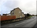
Stone built house, Witton Gilbert
This stands on Sacriston Lane, which is the more recent part of the village. Most of it is C20 but this house looks as though it could be earlier than that.
Image: © Robert Graham
Taken: 19 Nov 2014
0.02 miles
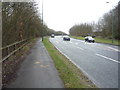
2
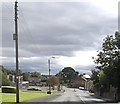
Sacriston Lane in Witton Gilbert
B6312 about to bear right to join the A691.
Image: © Stanley Howe
Taken: 21 Sep 2013
0.04 miles
3
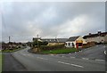
View south down Sacriston, Witton Gilbert
As its name suggests, Sacriston Lane leads up from the old village main street to the village of Sacriston to the north.
Image: © Robert Graham
Taken: 19 Nov 2014
0.04 miles
4
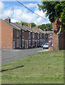
Newton Street, Witton Gilbert
Terraced housing in this village NW of the city of Durham.
Image: © Pauline E
Taken: 1 Jun 2013
0.16 miles
5
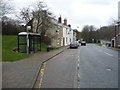
Bus stop and shelter on Front Street, Witton Gilbert
Image: © JThomas
Taken: 2 Apr 2016
0.17 miles
8
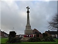
Witton Gilbert War Memorial
On Sacriston Road, in the C20 part of the village. I thought it might be on the old village street, but after all, this is where most of the men would have lived.
Image: © Robert Graham
Taken: 19 Nov 2014
0.21 miles
9
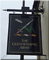
Sign for the Glendenning Arms, Witton Gilbert
Image: © JThomas
Taken: 2 Apr 2016
0.22 miles
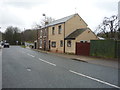
10
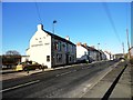
The Glendenning Arms, Witton Gilbert
The village is a very ancient one, and this buildings dates back to the 18th century probably. It used to have a thatched roof which blew off in a great storm in the 19th century. It takes its present name from a Victorian proprietor.
Image: © Robert Graham
Taken: 3 Apr 2013
0.23 miles