IMAGES TAKEN NEAR TO
Holmside, DURHAM, DH7 6EX
Introduction
This page details the photographs taken nearby to Holmside, DH7 6EX by members of the Geograph project.
The Geograph project started in 2005 with the aim of publishing, organising and preserving representative images for every square kilometre of Great Britain, Ireland and the Isle of Man.

There are currently over 7.5m images from over14,400 individuals and you can help contribute to the project by visiting https://www.geograph.org.uk
Image Map
Images are licensed for reuse under creativecommons.org/licenses/by-sa/2.0
Notes
- Clicking on the map will re-center to the selected point.
- The higher the marker number, the further away the image location is from the centre of the postcode.
Image Listing (18 Images Found)
Images are licensed for reuse under creativecommons.org/licenses/by-sa/2.0
Image
Details
Distance
1
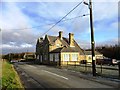
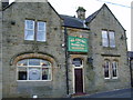
Wardle's Bridge Inn
On the minor road between Edmondsley and Burnhope.
Image: © Robert Graham
Taken: 28 Nov 2012
0.00 miles
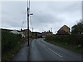
3
Holmside Lane entering Holmside
Holmside Lane passes a typical County Durham style, blue and yellow road sign, as it enters the small settlement of Holmside. The road also passes Wardle's Bridge Inn which is now closed and it seems, likely to be demolished and replaced by housing.
Image: © Trevor Littlewood
Taken: 21 Nov 2015
0.04 miles
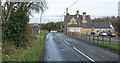
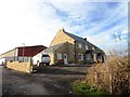
4
Wardle's Bridge Inn
Inn and restaurant now closed. The property is up for sale as a development opportunity with planning permission granted for ten mews type dwellings.
Image: © Oliver Dixon
Taken: 31 Oct 2014
0.04 miles
6

Highland cattle beside Charlaw Lane
Couple of rather muddy bulls. The Autumn weather has been very wet.
Image: © Robert Graham
Taken: 28 Nov 2012
0.11 miles
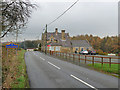
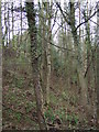
7
West Edmondsley Cottage Farm
View from the east, from Charlaw Lane.
Image: © Robert Graham
Taken: 28 Nov 2012
0.11 miles
9
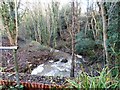
Whiteside Burn
At the point where it runs under the minor road from Edmondsley to Holmside.
Image: © Robert Graham
Taken: 28 Nov 2012
0.12 miles
10
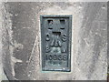
Ordnance Survey Flush Bracket 10938
This bracket can be found on the wall of a house at Holmside.
For more detail see : http://www.bench-marks.org.uk/bm2590
Image: © Peter Wood
Taken: 18 May 2012
0.12 miles