IMAGES TAKEN NEAR TO
Lanchester, DURHAM, DH7 0TA
Introduction
This page details the photographs taken nearby to DH7 0TA by members of the Geograph project.
The Geograph project started in 2005 with the aim of publishing, organising and preserving representative images for every square kilometre of Great Britain, Ireland and the Isle of Man.

There are currently over 7.5m images from over14,400 individuals and you can help contribute to the project by visiting https://www.geograph.org.uk
Image Map
Images are licensed for reuse under creativecommons.org/licenses/by-sa/2.0
Notes
- Clicking on the map will re-center to the selected point.
- The higher the marker number, the further away the image location is from the centre of the postcode.
Image Listing (9 Images Found)
Images are licensed for reuse under creativecommons.org/licenses/by-sa/2.0
Image
Details
Distance
1
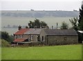
Close up of Land House farm
Viewed from the B6296 to the west. The south slope of the Pan Burn valley behind the farm.
Image: © Robert Graham
Taken: 29 Jul 2016
0.01 miles
2
View of Land House farm from the B6296
Looking east from the road with the south slopes of the Pan Burn valley beyond.
Image: © Robert Graham
Taken: 29 Jul 2016
0.02 miles
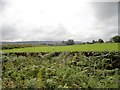
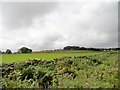
3
View south from the B6296
Looking across to Land House farm and beyond to the south slope of the Pan Burn valley.
Image: © Robert Graham
Taken: 29 Jul 2016
0.02 miles
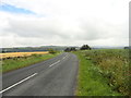
4
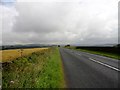
View north along the B6296
This country road runs NW here towards Lanchester. The view here looks along the Browney valley. Humber Hill in the distance.
Image: © Robert Graham
Taken: 29 Jul 2016
0.15 miles
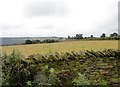
5
View south from the B6296
Looking across the fields to Hall Hill farmhouse which can be seen in the distance in the centre.
Image: © Robert Graham
Taken: 29 Jul 2016
0.16 miles
6
Looking north up the B6296
From a position just north of the entrance to Land House farm. A short way ahead, the road starts its descent into the Browney valley, the north slope of which can be seen in the distance. Humber Hill is on the horizon in the centre.
Image: © Robert Graham
Taken: 29 Jul 2016
0.18 miles
7
Agricultural diversification - the driveway to Hall Hill Farm
A visitor farm. http://www.hallhillfarm.co.uk
Image: © Oliver Dixon
Taken: 6 Mar 2007
0.21 miles
8
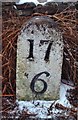
Old Milestone by the B6296, north east of Satley
Carved stone post by the B6296, in parish of SATLEY (DERWENTSIDE District), 170m North of Hall Hill Farm, on grass verge, on North side of road. Durham numbers stone, erected by the Lobley Hill & branches turnpike trust in the 18th century.
Inscription reads:-
17
6
(To Newcastle and Wolsingham)
Grade II Listed. List Entry Number:1185996
https://historicengland.org.uk/listing/the-list/list-entry/1185996
Milestone Society National ID: DU_GHWO17.
Image: © IA Davison
Taken: 16 Mar 2006
0.24 miles
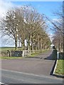
9
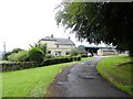
Hall Hill Farm
View of the farmhouse from the entrance drive. Hall Hill is an open farm with a lot of visitors, which probably accounts for the prosperous appearance.
Image: © Robert Graham
Taken: 29 Jul 2016
0.24 miles