IMAGES TAKEN NEAR TO
Deneside, DURHAM, DH7 0LZ
Introduction
This page details the photographs taken nearby to Deneside, DH7 0LZ by members of the Geograph project.
The Geograph project started in 2005 with the aim of publishing, organising and preserving representative images for every square kilometre of Great Britain, Ireland and the Isle of Man.

There are currently over 7.5m images from over14,400 individuals and you can help contribute to the project by visiting https://www.geograph.org.uk
Image Map (17 Images)

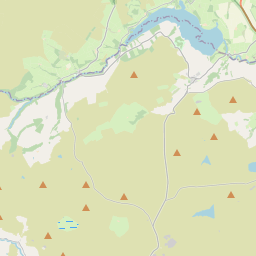

Leaflet Map data © OpenStreetMap
Images are licensed for reuse under creativecommons.org/licenses/by-sa/2.0
Notes
- Clicking on the map will re-center to the selected point.
- The higher the marker number, the further away the image location is from the centre of the postcode.
Image Listing (17 Images Found)
Images are licensed for reuse under creativecommons.org/licenses/by-sa/2.0
Image
Details
Distance
1
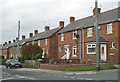
Red brick housing, Lanchester
Situated between Consett and Durham, this was formerly an agricultural village.
http://en.wikipedia.org/wiki/Lanchester,_County_Durham
Notable residents have included Canon William Greenwell (1820-1918), inventor of the popular 'Greenwell's Glory' fly-fishing fly. Not a lot of people know that.
Image: © Pauline E
Taken: 10 Oct 2009
0.09 miles
2

Lanchester sunrise
Marking the winter solstice and the first day of winter. Taken around 8.45.
Image: © Pauline E
Taken: 21 Dec 2009
0.10 miles
3
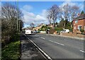
Looking along Durham Road Lanchester
View west along the A691 towards the village centre.
Image: © Robert Graham
Taken: 21 Feb 2022
0.14 miles
4
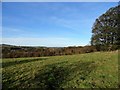
Trees along the Peth Burn
This stream on the west side of Lanchester village is screened by a narrow wood. The village can be seen on the far side. View from in front of Manor House farm on a nice autumn morning.
Image: © Robert Graham
Taken: 8 Nov 2017
0.16 miles
5
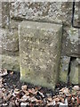
Old Bridge Marker on the A691 in Lanchester
Bridge Marker on the south side of the A691, against the bridge parapet of Warriors Bridge, Peth Burn. Lanchester parish. Inscribed WARRIORS / BRIDGE / 1932.
Milestone Society National ID: DU_LANC01br
Image: © Mike Rayner
Taken: 1 May 2019
0.17 miles
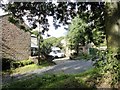
6
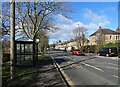
Bus stop on Durham Road
The main road into Lanchester from the east. The tower of the village church can be seen at the end of the street.
Image: © Robert Graham
Taken: 21 Feb 2022
0.18 miles
7
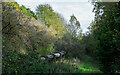
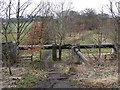
Pipeline passing through woodland
The woodland is owned or managed by the Woodland Trust and lies immediately south of Lanchester, adjacent to the Lanchester Valley Railway Path; the land is classified as access land under the year 2000 CROW Act. The pipeline carries sewage to a sewage works about half a kilometre away.
Image: © Trevor Littlewood
Taken: 20 Oct 2020
0.19 miles
8
Pipeline alongside the Lanchester Valley Railway Path
Probably a sewage pipe - there is a sewage works a short distance to the east.
Image: © Oliver Dixon
Taken: 15 Mar 2013
0.19 miles
9
Houses on Peth Bank
This road leads east out of Lanchester village up to Burnhope.
Image: © Robert Graham
Taken: 16 Aug 2012
0.21 miles