IMAGES TAKEN NEAR TO
Sunnybanks, DURHAM, DH7 0JW
Introduction
This page details the photographs taken nearby to Sunnybanks, DH7 0JW by members of the Geograph project.
The Geograph project started in 2005 with the aim of publishing, organising and preserving representative images for every square kilometre of Great Britain, Ireland and the Isle of Man.

There are currently over 7.5m images from over14,400 individuals and you can help contribute to the project by visiting https://www.geograph.org.uk
Image Map
Images are licensed for reuse under creativecommons.org/licenses/by-sa/2.0
Notes
- Clicking on the map will re-center to the selected point.
- The higher the marker number, the further away the image location is from the centre of the postcode.
Image Listing (24 Images Found)
Images are licensed for reuse under creativecommons.org/licenses/by-sa/2.0
Image
Details
Distance
1
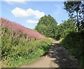
Railway Walk at Lanchester
The old railway going through a cutting on the western edge of the village. View looking west.
Image: © Robert Graham
Taken: 3 Aug 2021
0.03 miles
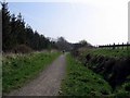
2
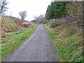
Lanchester Valley Railway Path
For most of its route, Lanchester Valley Path (part of National Cycle Network route 14) follows the line of the old railway from Durham to Lydgetts Junction, here seen just west of Lanchester village.
Image: © Oliver Dixon
Taken: 13 Nov 2012
0.05 miles
3
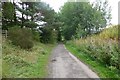
Lanchester Valley Railway Path
'The Lanchester Valley Railway Path is part of an extensive network of Railway Paths which are fantastic for cyclists, walkers and horse-riders. The Lanchester Valley railway opened in 1862 and was built to carry iron ore to Consett steelworks and coal from Langley Park; it closed in 1965.' https://www.thisisdurham.com/things-to-do/lanchester-valley-railway-path-walking-and-cycling-route-p666841
Image: © Russel Wills
Taken: 4 Sep 2018
0.06 miles
5
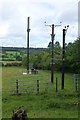
Communications mast and electricity poles
North west of Lanchester.
Image: © Russel Wills
Taken: 4 Sep 2018
0.09 miles
6
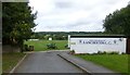
Entrance to Lanchester Cricket Club
Ashley Park, on Lanchester's northern fringe.
Image: © Russel Wills
Taken: 4 Sep 2018
0.10 miles
8
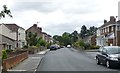
Kitswell Road, Lanchester
A residential street in this quiet village.
Image: © Russel Wills
Taken: 4 Sep 2018
0.13 miles
9
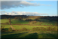
Fields near to Lanchester
The fields are close to Lanchester lying west from the village and are seen from the Lanchester Valley Railway Path.
Image: © Trevor Littlewood
Taken: 22 Nov 2014
0.13 miles
10
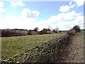
Looking west from the roadside near St Bede's school
View over the hedge at the roadside opposite the school. The Smallhope Burn lies on the other side of the bund on the left.
Image: © Robert Graham
Taken: 3 Apr 2013
0.14 miles