IMAGES TAKEN NEAR TO
Marlene Avenue, DURHAM, DH6 5EP
Introduction
This page details the photographs taken nearby to Marlene Avenue, DH6 5EP by members of the Geograph project.
The Geograph project started in 2005 with the aim of publishing, organising and preserving representative images for every square kilometre of Great Britain, Ireland and the Isle of Man.

There are currently over 7.5m images from over14,400 individuals and you can help contribute to the project by visiting https://www.geograph.org.uk
Image Map
Images are licensed for reuse under creativecommons.org/licenses/by-sa/2.0
Notes
- Clicking on the map will re-center to the selected point.
- The higher the marker number, the further away the image location is from the centre of the postcode.
Image Listing (15 Images Found)
Images are licensed for reuse under creativecommons.org/licenses/by-sa/2.0
Image
Details
Distance
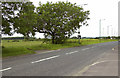
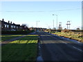
3
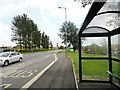
Bus stop at Bowburn
This is on the A177 at the northernmost end of the village. Viewed looking south. This road leads north to Durham City.
Image: © Robert Graham
Taken: 19 Jun 2013
0.13 miles
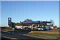
9
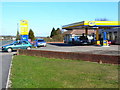
Jet petrol station on the A177, Bowburn
Image: © Oliver Dixon
Taken: 10 Apr 2006
0.19 miles