IMAGES TAKEN NEAR TO
Cassop, DURHAM, DH6 4RR
Introduction
This page details the photographs taken nearby to DH6 4RR by members of the Geograph project.
The Geograph project started in 2005 with the aim of publishing, organising and preserving representative images for every square kilometre of Great Britain, Ireland and the Isle of Man.

There are currently over 7.5m images from over14,400 individuals and you can help contribute to the project by visiting https://www.geograph.org.uk
Image Map
Images are licensed for reuse under creativecommons.org/licenses/by-sa/2.0
Notes
- Clicking on the map will re-center to the selected point.
- The higher the marker number, the further away the image location is from the centre of the postcode.
Image Listing (6 Images Found)
Images are licensed for reuse under creativecommons.org/licenses/by-sa/2.0
Image
Details
Distance
2
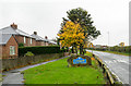
Houses in Cassop
The houses are beside the B6291 entering the old 'pit-village' of Cassop from the north-east. The blue and yellow road sign fixed to a rock is in the style in use in County Durham of some time; more typically such a sign would be raised on poles.
Image: © Trevor Littlewood
Taken: 29 Oct 2015
0.16 miles
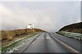
4
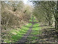
Footpath on disused railway trackbed at Cassop
Leading to Thornley in County Durham
Image: © Peter Robinson
Taken: 4 Apr 2010
0.18 miles
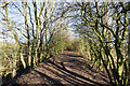
5
Footpath on railway trackbed towards Thornley
Leading from Cassop in County Durham
Image: © Peter Robinson
Taken: 4 Apr 2010
0.19 miles
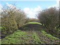
6
Footpath along old railway embankment
An old railway trackbed along a low embankment now in use as a footpath.
Image: © Trevor Littlewood
Taken: 18 Jan 2020
0.24 miles