IMAGES TAKEN NEAR TO
Steetley Terrace, DURHAM, DH6 4QJ
Introduction
This page details the photographs taken nearby to Steetley Terrace, DH6 4QJ by members of the Geograph project.
The Geograph project started in 2005 with the aim of publishing, organising and preserving representative images for every square kilometre of Great Britain, Ireland and the Isle of Man.

There are currently over 7.5m images from over14,400 individuals and you can help contribute to the project by visiting https://www.geograph.org.uk
Image Map
Images are licensed for reuse under creativecommons.org/licenses/by-sa/2.0
Notes
- Clicking on the map will re-center to the selected point.
- The higher the marker number, the further away the image location is from the centre of the postcode.
Image Listing (9 Images Found)
Images are licensed for reuse under creativecommons.org/licenses/by-sa/2.0
Image
Details
Distance

3
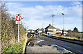
Traffic calming measures at Quarrington Hill
The B6291 approaching Quarrington Hill from the south-west where there's a chicane and a priority arrangement for traffic entering and leaving the village.
Image: © Trevor Littlewood
Taken: 7 Jan 2022
0.16 miles
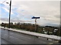
4
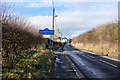
Road entering Quarrington from the south-east
The road is already alongside much of Quarrington which is to the left in the image, beyond the hedge. The road sign in blue with yellow trim and wording tells that the village is in County Durham.
Image: © Trevor Littlewood
Taken: 30 Jan 2019
0.18 miles
5
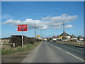
Entering Quarrington Hill from Coxhoe on the B6291
Image: © Bill Henderson
Taken: 9 Mar 2007
0.19 miles
7
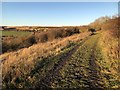
Track to Crow Trees Nature Reserve
Crow Trees Nature Reserve occupies a triangle of land bounded on two sides by a steep limestone escarpment. Once the location of mining activity with several early shafts sunk in the vicinity and a waggonway connection to the Clarence Railway at Coxhoe, the site contains the remains of the final colliery winding foundation, and ponds created using springs from the base of the escarpment to provide the mine with water.
Image: © David Robinson
Taken: 24 Dec 2018
0.22 miles
9
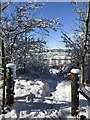
Snow covered footpath at Crowtrees nature Reserve
Image: © David Robinson
Taken: 10 Mar 2023
0.24 miles