IMAGES TAKEN NEAR TO
Kelloe, DURHAM, DH6 4PP
Introduction
This page details the photographs taken nearby to DH6 4PP by members of the Geograph project.
The Geograph project started in 2005 with the aim of publishing, organising and preserving representative images for every square kilometre of Great Britain, Ireland and the Isle of Man.

There are currently over 7.5m images from over14,400 individuals and you can help contribute to the project by visiting https://www.geograph.org.uk
Image Map
Images are licensed for reuse under creativecommons.org/licenses/by-sa/2.0
Notes
- Clicking on the map will re-center to the selected point.
- The higher the marker number, the further away the image location is from the centre of the postcode.
Image Listing (6 Images Found)
Images are licensed for reuse under creativecommons.org/licenses/by-sa/2.0
Image
Details
Distance
1
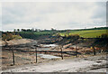
East Hetton Colliery Land Reclamation, Co. Durham
Removal of the coal slurry waste from the bottom of Kelloe Valley.
During coal mining operations prior to 1983 at East Hetton Colliery, a dam had been constructed across the valley to retain and store the coal slurry waste that was produced from the coal washing plant.
The reclamation works required the removal of the slurry from the valley, transporting it, and mixing it with the red shale of the pit heap to remodel the contours of the existing landscape.
Image]
Image]
Image: © Philip Soakell
Taken: Unknown
0.17 miles
2
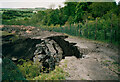
East Hetton Colliery Land Reclamation, Co. Durham
Progress photograph of land reclamation works in May 1991.
The image shows the removal of the coal slurry from the Kelloe Valley. The slurry coal waste fill was very unstable and contained pockets of water which if disturbed could result in the sudden collapse of the vertical face of the slurry. A crust would form on the top surface of the slurry and it would appear to be solid, yet beneath it was like a blancmange unable to support construction plant or persons walking on it. Temporary shale berms or temporary access roads had to be constructed to allow plant and equipment to access the slurry and remove it.
Image]
Image]
Image: © Philip Soakell
Taken: Unknown
0.17 miles
3
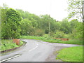
Parapets for road bridge over Kelloe Beck
Image: © Peter Robinson
Taken: 10 Jun 2012
0.20 miles
5
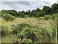
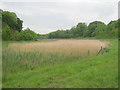
Kelloe Beck
Kelloe Beck at this point is a very small watercourse flowing past the site of the former East Hetton (Kelloe) Colliery. The entire area has undergone substantial change since the closure of the colliery in 1983. Downstream of this photograph (behind the photographer) the stream was dammed with a large earthwork adjacent to the colliery main entrance, and the valley was filled with the slurry from the coal washing plant. The resultant reservoir of solidified coal washings had to be mechanically dug out to return the valley to its natural state.
Image: © David Robinson
Taken: 17 Jul 2019
0.24 miles
6
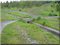
Footbridge for permissive path over drainage channel in Kelloe Plantation
Image: © Peter Robinson
Taken: 10 Jun 2012
0.25 miles