IMAGES TAKEN NEAR TO
Foundry Close, DURHAM, DH6 4LN
Introduction
This page details the photographs taken nearby to Foundry Close, DH6 4LN by members of the Geograph project.
The Geograph project started in 2005 with the aim of publishing, organising and preserving representative images for every square kilometre of Great Britain, Ireland and the Isle of Man.

There are currently over 7.5m images from over14,400 individuals and you can help contribute to the project by visiting https://www.geograph.org.uk
Image Map
Images are licensed for reuse under creativecommons.org/licenses/by-sa/2.0
Notes
- Clicking on the map will re-center to the selected point.
- The higher the marker number, the further away the image location is from the centre of the postcode.
Image Listing (12 Images Found)
Images are licensed for reuse under creativecommons.org/licenses/by-sa/2.0
Image
Details
Distance
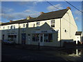
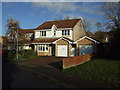
4
Housing alongside B6291
New housing beyond open ground with a few deciduous trees at the northern end of Coxhoe.
Image: © Trevor Littlewood
Taken: 7 Jan 2022
0.20 miles
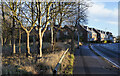
5
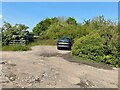
Coxhoe railway station (site), County Durham
Opened in 1838 by the Clarence Railway, later part of the North Eastern Railway, as the terminus of its line from Stockton, this tiny station closed to passengers in 1902 and completely in 1966.
View north, towards a level crossing, the gates of which were still there when this image was taken but were hidden by shrubs. The wall at the back of (what was a very low) single platform is still there, beyond the fence on the left. The former goods shed, behind the camera position, was also still extant.
For more information, see http://www.disused-stations.org.uk/c/coxhoe/index.shtml
Image: © Nigel Thompson
Taken: 29 May 2021
0.21 miles
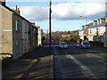
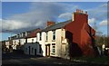
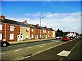
8
West Terrace, Coxhoe
Old street of houses at the north end of this former mining village south of Durham.
Image: © Robert Graham
Taken: 19 Jun 2013
0.22 miles
9
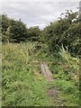
Footpath,Coxhoe
Footpath crossing boggy ground beside the course of the old railway / waggonway that served the first Bowburn Colliery, then the lime works at Coxhoe.
Image: © David Robinson
Taken: 27 Aug 2018
0.22 miles
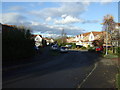
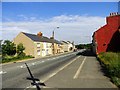
10
Looking north along the B6291 at Coxhoe
This is the road which runs right through the village, leading to Durham City a few miles away.
Image: © Robert Graham
Taken: 19 Jun 2013
0.22 miles