IMAGES TAKEN NEAR TO
Meadow View, DURHAM, DH6 4DZ
Introduction
This page details the photographs taken nearby to Meadow View, DH6 4DZ by members of the Geograph project.
The Geograph project started in 2005 with the aim of publishing, organising and preserving representative images for every square kilometre of Great Britain, Ireland and the Isle of Man.

There are currently over 7.5m images from over14,400 individuals and you can help contribute to the project by visiting https://www.geograph.org.uk
Image Map (Loading...)


Getting Data...Please wait
Leaflet Map data © OpenStreetMap
Images are licensed for reuse under creativecommons.org/licenses/by-sa/2.0
Notes
- Clicking on the map will re-center to the selected point.
- The higher the marker number, the further away the image location is from the centre of the postcode.
Image Listing (19 Images Found)
Images are licensed for reuse under creativecommons.org/licenses/by-sa/2.0
Image
Details
Distance
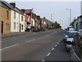
1
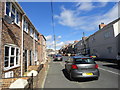
Looking north up Cornforth Lane, Coxhoe
This long street leads SW from the main street in Coxhoe village. Some houses are shown along it on the 1903 Ordnance Survey map, but obviously buildings have been erected along here at various points in the 20th century.
Image: © Robert Graham
Taken: 18 Sep 2013
0.05 miles
4
Looking towards East Pasture House
This farm lies at the south west corner of Coxhoe village. Viewed from Cornforth Lane.
Image: © Robert Graham
Taken: 18 Sep 2013
0.17 miles
5
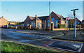
Coxhoe Primary School
The school is at the south-western corner of the village close to a roundabout on the A177 and also to the A1(M).
Image: © Trevor Littlewood
Taken: 20 Jan 2020
0.18 miles
7
Bogma Hall Farm, Coxhoe
Farm at the south end of the village.
Image: © Robert Graham
Taken: 19 Jun 2013
0.21 miles
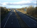
9
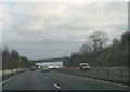
The A1(M) southbound
Approaching the A177 overbridge
Image: © Peter Robinson
Taken: 1 Dec 2013
0.22 miles
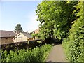
10
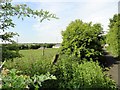
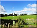
View south from the path to Bogma Hall Farm
This lane is at the south end of Coxhoe village. The farm outbuildings can be seen on the right.
Image: © Robert Graham
Taken: 19 Jun 2013
0.23 miles