IMAGES TAKEN NEAR TO
Johnson Estate, DURHAM, DH6 3LH
Introduction
This page details the photographs taken nearby to Johnson Estate, DH6 3LH by members of the Geograph project.
The Geograph project started in 2005 with the aim of publishing, organising and preserving representative images for every square kilometre of Great Britain, Ireland and the Isle of Man.

There are currently over 7.5m images from over14,400 individuals and you can help contribute to the project by visiting https://www.geograph.org.uk
Image Map
Images are licensed for reuse under creativecommons.org/licenses/by-sa/2.0
Notes
- Clicking on the map will re-center to the selected point.
- The higher the marker number, the further away the image location is from the centre of the postcode.
Image Listing (8 Images Found)
Images are licensed for reuse under creativecommons.org/licenses/by-sa/2.0
Image
Details
Distance
2
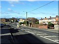
Footpath north from Byron Street Wheatley Hill
Image: © Peter Robinson
Taken: 9 Nov 2010
0.16 miles
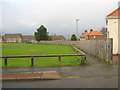
4
Wingate Lane
Once the main road to Wingate. Now a quiet cul-de-sac.
Image: © Roger Smith
Taken: 22 Feb 2009
0.20 miles
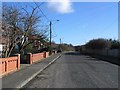
5
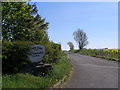
Access to Old Wingate Farm
Branching from the A181, this is a private road but has a public footpath along it
Image: © John Slater
Taken: 27 May 2012
0.22 miles
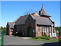
6

Fire station, Wheatley Hill
On the north side of Wingate Lane with the Abbots Court residential care home beyond.
Image: © Trevor Littlewood
Taken: 18 Jan 2020
0.22 miles
7

Petrol Filling Station
On the outskirts of Wheatley Hill on the A181 Durham to A19 road
Image: © George Ford
Taken: 10 Aug 2005
0.23 miles
8
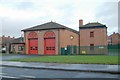
Wheatley Hill fire station
Wheatley Hill fire station, Wingate Lane South, Wheatley Hill, County Durham, with unusual shaping above the appliance bay doors, possibly designed to imitate the shapes seen on the mining architecture that was once prevalent in the area.
Image: © Kevin Hale
Taken: 27 Nov 2006
0.23 miles