IMAGES TAKEN NEAR TO
Dunelm Road, DURHAM, DH6 3HP
Introduction
This page details the photographs taken nearby to Dunelm Road, DH6 3HP by members of the Geograph project.
The Geograph project started in 2005 with the aim of publishing, organising and preserving representative images for every square kilometre of Great Britain, Ireland and the Isle of Man.

There are currently over 7.5m images from over14,400 individuals and you can help contribute to the project by visiting https://www.geograph.org.uk
Image Map
Images are licensed for reuse under creativecommons.org/licenses/by-sa/2.0
Notes
- Clicking on the map will re-center to the selected point.
- The higher the marker number, the further away the image location is from the centre of the postcode.
Image Listing (7 Images Found)
Images are licensed for reuse under creativecommons.org/licenses/by-sa/2.0
Image
Details
Distance
1
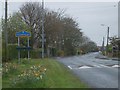
Thornley Bumps
The Dunelm Road into Thornley Village.
Image: © Gordon Griffiths
Taken: 20 Apr 2007
0.08 miles
2
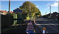
Approaching Thornley
Approaching the village of Thornley on the B1279.
Image: © Chris Thomas-Atkin
Taken: 2 Oct 2017
0.08 miles
3
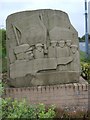
Thornley Plaque
A Sculpture to the mining history of Thornley.
Image: © Gordon Griffiths
Taken: 20 Apr 2007
0.11 miles
4
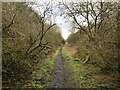
Old Waggonway, Thornley
Route of an old colliery waggonway linking Cassop and Thornley.
Image: © David Robinson
Taken: 5 Mar 2021
0.12 miles
5
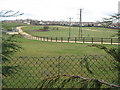
Gallop at Thornley County Durham
For training trotting horses
Image: © Peter Robinson
Taken: 4 Apr 2010
0.12 miles
6

Mast and Rape
The view from the Dunelem Road Thornley.
Image: © Gordon Griffiths
Taken: 20 Apr 2007
0.13 miles
7
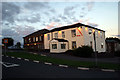
Crossways Hotel
Situated on the outskirts of Thornley Co. Durham. Its only claim to fame is that Prince Harry once slept there.
Image: © George Ford
Taken: 10 Aug 2005
0.18 miles