IMAGES TAKEN NEAR TO
South Hetton, DURHAM, DH6 2SZ
Introduction
This page details the photographs taken nearby to DH6 2SZ by members of the Geograph project.
The Geograph project started in 2005 with the aim of publishing, organising and preserving representative images for every square kilometre of Great Britain, Ireland and the Isle of Man.

There are currently over 7.5m images from over14,400 individuals and you can help contribute to the project by visiting https://www.geograph.org.uk
Image Map
Images are licensed for reuse under creativecommons.org/licenses/by-sa/2.0
Notes
- Clicking on the map will re-center to the selected point.
- The higher the marker number, the further away the image location is from the centre of the postcode.
Image Listing (2 Images Found)
Images are licensed for reuse under creativecommons.org/licenses/by-sa/2.0
Image
Details
Distance
1
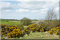
Bushes near to Haswell to Hart Countryside Walkway
Gorse and blackthorn in flower on the west side of the Haswell to Hart Countryside Walkway.
Image: © Trevor Littlewood
Taken: 3 May 2018
0.16 miles
2
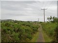
South Hetton Railway
A branch of Braddyll's Railway up to Haswell. Some of the railway trackbeds here have dips in them where coal was taken from them during the 1984-85 miners' strike. When the embankments were built, they used cheap local materials including lower quality coal. During the winter of the strike, miners families heated their homes with coal won from disused embankments.
Image: © Richard Webb
Taken: 9 Aug 2016
0.18 miles