IMAGES TAKEN NEAR TO
Gregson Terrace, DURHAM, DH6 2SX
Introduction
This page details the photographs taken nearby to Gregson Terrace, DH6 2SX by members of the Geograph project.
The Geograph project started in 2005 with the aim of publishing, organising and preserving representative images for every square kilometre of Great Britain, Ireland and the Isle of Man.

There are currently over 7.5m images from over14,400 individuals and you can help contribute to the project by visiting https://www.geograph.org.uk
Image Map
Images are licensed for reuse under creativecommons.org/licenses/by-sa/2.0
Notes
- Clicking on the map will re-center to the selected point.
- The higher the marker number, the further away the image location is from the centre of the postcode.
Image Listing (7 Images Found)
Images are licensed for reuse under creativecommons.org/licenses/by-sa/2.0
Image
Details
Distance
3
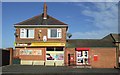
Convenience store and post office, South Hetton
Image: © JThomas
Taken: 10 Nov 2012
0.17 miles
6
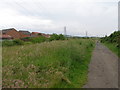
Power lines follow the route of the countryside walk
Image: © Carol Rose
Taken: 23 Jun 2007
0.22 miles