IMAGES TAKEN NEAR TO
Queen Street, DURHAM, DH6 2QR
Introduction
This page details the photographs taken nearby to Queen Street, DH6 2QR by members of the Geograph project.
The Geograph project started in 2005 with the aim of publishing, organising and preserving representative images for every square kilometre of Great Britain, Ireland and the Isle of Man.

There are currently over 7.5m images from over14,400 individuals and you can help contribute to the project by visiting https://www.geograph.org.uk
Image Map
Images are licensed for reuse under creativecommons.org/licenses/by-sa/2.0
Notes
- Clicking on the map will re-center to the selected point.
- The higher the marker number, the further away the image location is from the centre of the postcode.
Image Listing (3 Images Found)
Images are licensed for reuse under creativecommons.org/licenses/by-sa/2.0
Image
Details
Distance
1
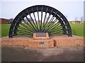
Memorial Pit Wheel Shotton Colliery
Pit wheel with names of miners killed in the pit at Shotton Colliery
Image: © Barry Wood
Taken: 19 Jan 2008
0.21 miles
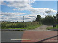
3
Cycle path following route of former railway
Approaching a high level footbridge that is the only link between two housing estates bisected by the former Hart to Haswell railway route
Image: © Kevin Waterhouse
Taken: 14 Jun 2023
0.25 miles