IMAGES TAKEN NEAR TO
Salters Lane, DURHAM, DH6 2PZ
Introduction
This page details the photographs taken nearby to Salters Lane, DH6 2PZ by members of the Geograph project.
The Geograph project started in 2005 with the aim of publishing, organising and preserving representative images for every square kilometre of Great Britain, Ireland and the Isle of Man.

There are currently over 7.5m images from over14,400 individuals and you can help contribute to the project by visiting https://www.geograph.org.uk
Image Map
Images are licensed for reuse under creativecommons.org/licenses/by-sa/2.0
Notes
- Clicking on the map will re-center to the selected point.
- The higher the marker number, the further away the image location is from the centre of the postcode.
Image Listing (3 Images Found)
Images are licensed for reuse under creativecommons.org/licenses/by-sa/2.0
Image
Details
Distance
1
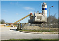
Ready-mixed concrete plant
The Cemex depot at Thornley Station Industrial Estate.
Image: © Trevor Littlewood
Taken: 3 May 2018
0.13 miles
2
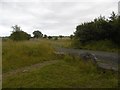
Road to Edder Acres
An unsealed road crosses the railway path.
Image: © Richard Webb
Taken: 9 Aug 2016
0.17 miles
3
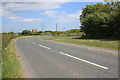
The B1279 road near Greenhills
This photograph shows a view of the bends in the B1279 road as it passes Greenhills (to the right of the trees). The industrial estate can just be seen on the horizon - as can the pylon run that passes over it. The picture was taken looking in an easterly direction towards Shotton.
Image: © Philip Barker
Taken: 2 Jun 2010
0.24 miles