IMAGES TAKEN NEAR TO
Mazine Terrace, DURHAM, DH6 2EF
Introduction
This page details the photographs taken nearby to Mazine Terrace, DH6 2EF by members of the Geograph project.
The Geograph project started in 2005 with the aim of publishing, organising and preserving representative images for every square kilometre of Great Britain, Ireland and the Isle of Man.

There are currently over 7.5m images from over14,400 individuals and you can help contribute to the project by visiting https://www.geograph.org.uk
Image Map
Images are licensed for reuse under creativecommons.org/licenses/by-sa/2.0
Notes
- Clicking on the map will re-center to the selected point.
- The higher the marker number, the further away the image location is from the centre of the postcode.
Image Listing (8 Images Found)
Images are licensed for reuse under creativecommons.org/licenses/by-sa/2.0
Image
Details
Distance
1
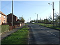
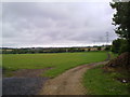
Looking West near Haswell
View from the road between Haswell and Haswell Plough. Nice view of the windfarm on Haswell Moor.
Image: © Robert Graham
Taken: 12 Jul 2011
0.17 miles
2
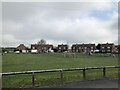
Children's park / play area, Haswell Plough
Image: © David Robinson
Taken: 20 Apr 2022
0.17 miles
3
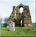
Ruin of Haswell pumping engine building
The ruined building with immensely thick walls was built to house a steam engine which drove pumping equipment that drained Haswell Colliery lying to the east of the village, Haswell Plough. The colliery was closed in the 1890's, the last working shift at Haswell was on the 25th September 1896. [Source: Newcastle Daily Chronicle Saturday 26th September 1896]: thanks to Philip Soakell for the added detail.
The sculpture commemorates the pit disaster of 1844 when 95 men and boys were killed. There seems to have been some re-working of the carved faces on the front of the monument - they appear to be much more 'clean-cut' than others.
Image: © Trevor Littlewood
Taken: 9 Apr 2018
0.17 miles
4
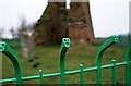
Fence around Haswell Engine House
Easily missed, faces on the metal fence protecting the ruins of Haswell Colliery Engine House. In 1844 an underground explosion killed 95 men and boys working in the pit, only 6 survived. There is a carved stone memorial here, to the left in my photo, but the loss of life is also marked by the faces on the fence.
Image: © Roger Muggleton
Taken: 27 Dec 2019
0.19 miles
5
View East from Haswell
Looking East from the road just South of the village.
Image: © Robert Graham
Taken: 12 Jul 2011
0.21 miles
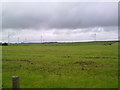
6
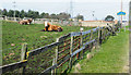
Cattle behind complex fence
As the blue and yellow road sign informs, the cattle are in a field close to the County Durham village of Haswell.
The assumption was that the cattle were English Longhorns but an enquiry of the Longhorn Cattle Society brought the following response....
"The cattle aren’t Longhorns, the one in the foreground is a Simmental or Simmental cross and the one in the background is probably a Shorthorn crossed with a Charolais."
Image: © Trevor Littlewood
Taken: 9 Apr 2018
0.21 miles
7
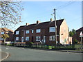
Houses on Gloucester Terrace, Haswell Plough
Image: © JThomas
Taken: 19 Nov 2011
0.23 miles