IMAGES TAKEN NEAR TO
Maplewood Drive, DURHAM, DH6 2BX
Introduction
This page details the photographs taken nearby to Maplewood Drive, DH6 2BX by members of the Geograph project.
The Geograph project started in 2005 with the aim of publishing, organising and preserving representative images for every square kilometre of Great Britain, Ireland and the Isle of Man.

There are currently over 7.5m images from over14,400 individuals and you can help contribute to the project by visiting https://www.geograph.org.uk
Image Map
Images are licensed for reuse under creativecommons.org/licenses/by-sa/2.0
Notes
- Clicking on the map will re-center to the selected point.
- The higher the marker number, the further away the image location is from the centre of the postcode.
Image Listing (8 Images Found)
Images are licensed for reuse under creativecommons.org/licenses/by-sa/2.0
Image
Details
Distance
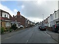
2
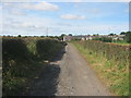
Haswell 2nd railway station (site), County Durham
Opened in 1858 by the North Eastern Railway on the line from Sunderland to Hartlepool, this station replaced an earlier terminus station nearby. In turn, this station closed in 1952 and the site was redeveloped.
View south east from the former level crossing along the track-bed, which crossed the road diagonally. The station's two platforms started immediately on the other side of the road, with the main station building standing roughly where the modern house on the right now stands. No trace now remains.
Image: © Nigel Thompson
Taken: 19 Mar 2020
0.09 miles
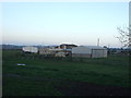
8
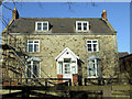
Pesspool Hall, Hall Lane, Haswell
Pesspool Hall, Haswell photographed on the 28th November 2008.
The building was later demolished.
Image: © Philip Soakell
Taken: 28 Nov 2008
0.25 miles