IMAGES TAKEN NEAR TO
Kestrel Way, DURHAM, DH6 2BF
Introduction
This page details the photographs taken nearby to Kestrel Way, DH6 2BF by members of the Geograph project.
The Geograph project started in 2005 with the aim of publishing, organising and preserving representative images for every square kilometre of Great Britain, Ireland and the Isle of Man.

There are currently over 7.5m images from over14,400 individuals and you can help contribute to the project by visiting https://www.geograph.org.uk
Image Map
Images are licensed for reuse under creativecommons.org/licenses/by-sa/2.0
Notes
- Clicking on the map will re-center to the selected point.
- The higher the marker number, the further away the image location is from the centre of the postcode.
Image Listing (12 Images Found)
Images are licensed for reuse under creativecommons.org/licenses/by-sa/2.0
Image
Details
Distance
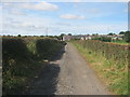
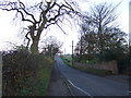
1
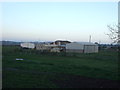
Haswell 2nd railway station (site), County Durham
Opened in 1858 by the North Eastern Railway on the line from Sunderland to Hartlepool, this station replaced an earlier terminus station nearby. In turn, this station closed in 1952 and the site was redeveloped.
View south east from the former level crossing along the track-bed, which crossed the road diagonally. The station's two platforms started immediately on the other side of the road, with the main station building standing roughly where the modern house on the right now stands. No trace now remains.
Image: © Nigel Thompson
Taken: 19 Mar 2020
0.06 miles
6
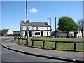
Crown Cottage, Church Street, Haswell, County Durham
Image: © Peter Robinson
Taken: 2 Sep 2012
0.23 miles
7
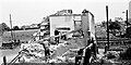
Demolition of Bankhead Railway Station on 31st May 1964
The "Haswell Bridge" station was located near to Salters Road, at the north end of Haswell Village and was the terminus for the Hartlepool Dock Railway. The boys on the left of the picture are sitting on the parapet wall to the tunnel that was constructed under the Hartlepool railway, to allow the Sunderland & Durham Branch railway to connect with the Haswell Colliery line. There was a railway siding off the Haswell Colliery line (west of this tunnel) which led back up at right angles to Bankhead Station.
A turntable was used at the Bankhead Station to turn locomotives and third-class passenger carriages around to make a connection between the Hartlepool and Sunderland Railways.
Haswell Junction station (passenger terminus) on the Sunderland Railway was to the east of the Bankhead Station, where the 1st-class passengers had to disembark and be transported across to Bankhead for ongoing passage to Hartlepool (the tunnel under Salters Road was only large enough to allow the passage of third class and baggage carriages).
The railway station which replaced the Bankhead station can be seen in the background just beyond the level crossing and signal box at Station Street.
As a young boy I lived in Railway Cottages which can be seen on the extreme right of the image.
Further details of the arrangement and configuration of the railway lines at Bankhead are described in Parliamentary Papers which investigate a derailment on the colliery line/ sidings points.
Image: © FredSoakell
Taken: 31 May 1964
0.23 miles
8
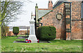
War memorial at Haswell
Haswell's war memorial is at the north-western angle of St Paul's Church.
Image: © Trevor Littlewood
Taken: 9 Apr 2018
0.23 miles