IMAGES TAKEN NEAR TO
Haswell, DURHAM, DH6 2AP
Introduction
This page details the photographs taken nearby to DH6 2AP by members of the Geograph project.
The Geograph project started in 2005 with the aim of publishing, organising and preserving representative images for every square kilometre of Great Britain, Ireland and the Isle of Man.

There are currently over 7.5m images from over14,400 individuals and you can help contribute to the project by visiting https://www.geograph.org.uk
Image Map
Images are licensed for reuse under creativecommons.org/licenses/by-sa/2.0
Notes
- Clicking on the map will re-center to the selected point.
- The higher the marker number, the further away the image location is from the centre of the postcode.
Image Listing (20 Images Found)
Images are licensed for reuse under creativecommons.org/licenses/by-sa/2.0
Image
Details
Distance
5

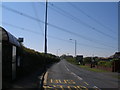
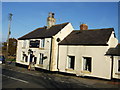
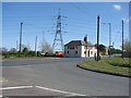
The Blue House Pemberton Arms, Haswell
At the crossroads of the B1283 and B1280
Image: © Oliver Dixon
Taken: 10 Apr 2006
0.04 miles
6
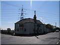
Pub with a pylon.
This pub with a pylon to the rear , is the Blue House, Haswell
Image: © Bill Henderson
Taken: 26 Apr 2007
0.04 miles