IMAGES TAKEN NEAR TO
George Square, DURHAM, DH6 1LW
Introduction
This page details the photographs taken nearby to George Square, DH6 1LW by members of the Geograph project.
The Geograph project started in 2005 with the aim of publishing, organising and preserving representative images for every square kilometre of Great Britain, Ireland and the Isle of Man.

There are currently over 7.5m images from over14,400 individuals and you can help contribute to the project by visiting https://www.geograph.org.uk
Image Map
Images are licensed for reuse under creativecommons.org/licenses/by-sa/2.0
Notes
- Clicking on the map will re-center to the selected point.
- The higher the marker number, the further away the image location is from the centre of the postcode.
Image Listing (12 Images Found)
Images are licensed for reuse under creativecommons.org/licenses/by-sa/2.0
Image
Details
Distance
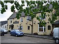
3
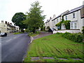
Village street in Shadforth
Looking down the main street from the East.
Image: © Robert Graham
Taken: 12 Jul 2011
0.05 miles
4
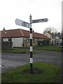
Old Direction Sign - Signpost in Shadforth, Durham
Cone finial - 2 arms; by the UC road, in parish of Shadforth (Durham District), South Side, at junction with Oliver Crescent.
Surveyed
Milestone Society National ID: DU_NZ3440
Image: © Milestone Society
Taken: Unknown
0.06 miles
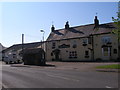
5
West end of the village street in Shadforth
Image: © Robert Graham
Taken: 12 Jul 2011
0.09 miles
6
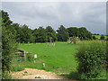
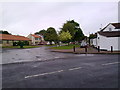
The Village Green, Southside, Shadforth
Image: © Roger Smith
Taken: 13 May 2007
0.10 miles
7
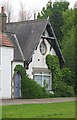
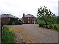
Copeley House: for 101 years Shadforth village school
Built in 1863 as the National School its title was changed to Shadforth Church of England School in 1907. As many as 127 children were taught here in 1922. In more recent times school numbers fell considerably and the school was closed in 1964, being converted to a private house. Much more information in Shadforth - a village history produced by the Shadforth History Group.
Image: © Roger Smith
Taken: 13 May 2007
0.12 miles
8
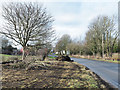
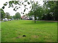
Damaged grass verge of Chare Lane
Chare Lane is seen approaching Shadforth from the east. Several trees on the verge have been removed - some branch debris is in view. Machinery, including a track-laying vehicle, has run along the verge temporarily muddying its surface. Buildings in Shadforth can be seen ahead, also a typical County Durham road sign naming it in a blue and yellow livery.
Image: © Trevor Littlewood
Taken: 25 Jan 2019
0.13 miles