IMAGES TAKEN NEAR TO
Latimer Way, DURHAM, DH6 1BU
Introduction
This page details the photographs taken nearby to Latimer Way, DH6 1BU by members of the Geograph project.
The Geograph project started in 2005 with the aim of publishing, organising and preserving representative images for every square kilometre of Great Britain, Ireland and the Isle of Man.

There are currently over 7.5m images from over14,400 individuals and you can help contribute to the project by visiting https://www.geograph.org.uk
Image Map
Images are licensed for reuse under creativecommons.org/licenses/by-sa/2.0
Notes
- Clicking on the map will re-center to the selected point.
- The higher the marker number, the further away the image location is from the centre of the postcode.
Image Listing (16 Images Found)
Images are licensed for reuse under creativecommons.org/licenses/by-sa/2.0
Image
Details
Distance
1
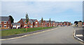
New Houses, Latimer Way
Still being built up the far end of the road. A new development on the edge of Sherburn.
Image: © Des Blenkinsopp
Taken: 28 Aug 2022
0.05 miles
2
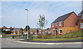
Latimer Way, Sherburn
New housing on the edge of the village.
Image: © Des Blenkinsopp
Taken: 28 Aug 2022
0.07 miles
3
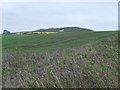
Sherburn Way View
A view from the path south of Sherburn.
Image: © Gordon Griffiths
Taken: 20 Apr 2007
0.10 miles
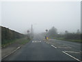
4
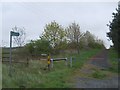
Sherburn Way Junction
The path crosses a minor road south of Sherburn.
Image: © Gordon Griffiths
Taken: 20 Apr 2007
0.12 miles
5
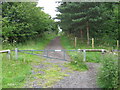
Access to Sherburn Woods from the eastern side of the road just south of Sherburn
Image: © Peter Robinson
Taken: 12 Jul 2011
0.13 miles
6
Field and hedge close to Sherburn
The field with a recently emerged crop lies to the south-east of Sherburn.
Image: © Trevor Littlewood
Taken: 20 Jan 2017
0.13 miles
8
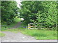
Access to Sherburn Way on the western side of the road just south of Sherburn
Image: © Peter Robinson
Taken: 12 Jul 2011
0.15 miles
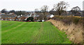
9
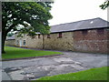
Sherburn Farm
Old farm buildings near the village centre.
Image: © Robert Graham
Taken: 12 Jul 2011
0.15 miles
10
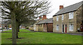
Houses and farm in Sherburn
Sherburn is a village astride the B1283 lying to the west of Durham city. The buildings in view are at the eastern end of the settlement and on the south side of the main road.
Image: © Trevor Littlewood
Taken: 20 Jan 2017
0.16 miles