IMAGES TAKEN NEAR TO
Colliery Lane, HOUGHTON LE SPRING, DH5 0QZ
Introduction
This page details the photographs taken nearby to Colliery Lane, DH5 0QZ by members of the Geograph project.
The Geograph project started in 2005 with the aim of publishing, organising and preserving representative images for every square kilometre of Great Britain, Ireland and the Isle of Man.

There are currently over 7.5m images from over14,400 individuals and you can help contribute to the project by visiting https://www.geograph.org.uk
Image Map
Images are licensed for reuse under creativecommons.org/licenses/by-sa/2.0
Notes
- Clicking on the map will re-center to the selected point.
- The higher the marker number, the further away the image location is from the centre of the postcode.
Image Listing (3 Images Found)
Images are licensed for reuse under creativecommons.org/licenses/by-sa/2.0
Image
Details
Distance
1
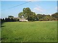
Farmland at Little Eppleton Farm
Image: © GRAEME and LESLEY CRANSTON
Taken: 23 Sep 2006
0.05 miles
2
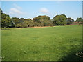
Farmland near Eppleton Hall
Image: © GRAEME and LESLEY CRANSTON
Taken: 23 Sep 2006
0.11 miles
3
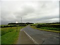
View east along the B1285
At the south east side of Hetton-le-Hole. This road continues along from Colliery Lane towards Murton. Grotto Plantation on the left.
Image: © Robert Graham
Taken: 3 Jul 2013
0.23 miles