IMAGES TAKEN NEAR TO
Dentdale, HOUGHTON LE SPRING, DH4 7QQ
Introduction
This page details the photographs taken nearby to Dentdale, DH4 7QQ by members of the Geograph project.
The Geograph project started in 2005 with the aim of publishing, organising and preserving representative images for every square kilometre of Great Britain, Ireland and the Isle of Man.

There are currently over 7.5m images from over14,400 individuals and you can help contribute to the project by visiting https://www.geograph.org.uk
Image Map
Images are licensed for reuse under creativecommons.org/licenses/by-sa/2.0
Notes
- Clicking on the map will re-center to the selected point.
- The higher the marker number, the further away the image location is from the centre of the postcode.
Image Listing (8 Images Found)
Images are licensed for reuse under creativecommons.org/licenses/by-sa/2.0
Image
Details
Distance
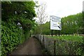
3
Weardale Way beside the A182
The long distance footpath has been granted a segregated channel to guide its trail back to the River Wear at Chartershaugh Bridge
Image: © Chris Heaton
Taken: 18 May 2023
0.17 miles
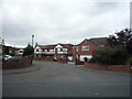
4
Approaching the A182
The Weardale Way heading towards the outskirts of Washington
Image: © Tim Heaton
Taken: 18 May 2023
0.18 miles
5
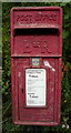
Close up, Elizabeth II postbox on Station Road, Penshaw
Postbox No. DH4 30.
See Image] for wider view.
Image: © JThomas
Taken: 18 Aug 2018
0.18 miles
6
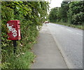
Elizabeth II postbox on Station Road, Penshaw
Postbox No. DH4 30.
See Image] for close up.
Image: © JThomas
Taken: 18 Aug 2018
0.18 miles
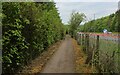
8
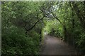
Weardale Way in a Green Tunnel beside the A182
Image: © Chris Heaton
Taken: 18 May 2023
0.19 miles