IMAGES TAKEN NEAR TO
Penshaw, HOUGHTON LE SPRING, DH4 7NQ
Introduction
This page details the photographs taken nearby to DH4 7NQ by members of the Geograph project.
The Geograph project started in 2005 with the aim of publishing, organising and preserving representative images for every square kilometre of Great Britain, Ireland and the Isle of Man.

There are currently over 7.5m images from over14,400 individuals and you can help contribute to the project by visiting https://www.geograph.org.uk
Image Map
Images are licensed for reuse under creativecommons.org/licenses/by-sa/2.0
Notes
- Clicking on the map will re-center to the selected point.
- The higher the marker number, the further away the image location is from the centre of the postcode.
Image Listing (19 Images Found)
Images are licensed for reuse under creativecommons.org/licenses/by-sa/2.0
Image
Details
Distance
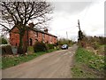
1
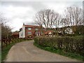
Low Lambton Farm
Victorian farm at Penshaw.
Image: © Robert Graham
Taken: 24 Apr 2013
0.02 miles
2
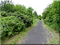
Wild roses beside the old railway line
A path follows the line of the old railway which linked Penshaw on the Leamside Line with Sunderland. This view is just to the north of the junction.
Image: © Oliver Dixon
Taken: 19 Jun 2015
0.09 miles
3
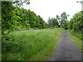
Junction on the Leamside Line
The Leamside Line which can be seen to the left is the mothballed railway which runs parallel to the East Coast Main Line between Ferryhill and Newcastle. The trackbed and ballast has been preserved against possible re-opening although the track has been removed (some of it stolen as on this section).
To the right is the line of the old branch line to Sunderland.
Image: © Oliver Dixon
Taken: 19 Jun 2015
0.10 miles
4

Field with emerging crop on slope of Penshaw Hill
The waterlogged field is above Coxgreen Road. The building at the top of Penshaw Hill is the Penshaw Monument, considered to be a a folly. It was built between 1844 and 1845 and is grade 1 listed.
Image: © Trevor Littlewood
Taken: 18 Feb 2021
0.16 miles
5
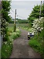
Unadopted road to Low Lambton Farm (old wagonway)
This was in the 19th century the route of a wagonway to Low Lambton Staithes. Now used for access to the farm and by walkers.
Image: © Brian Abbott
Taken: 27 May 2006
0.17 miles
6
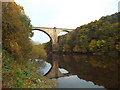
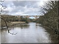
River Wear near Washington
A disused railway viaduct crosses the River Wear near Washington.
Image: © Malc McDonald
Taken: 29 Oct 2016
0.19 miles
7
Railway Cottages, Penshaw
Victorian terrace beside what used to be the main east line until 1872. Located just north of Penshaw village.
Image: © Robert Graham
Taken: 24 Apr 2013
0.19 miles
9
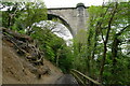
The Weardale Way passing beneath Victoria Viaduct
The railway viaduct was built in 1838, the year of Victoria's coronation, and was one of the largest bridges in Europe. It carried trains until 1991, since when it has been mothballed https://www.bridgesonthetyne.co.uk/fatvic.html .
Next to the path an unstable beech tree has been recently felled
Image: © Tim Heaton
Taken: 18 May 2023
0.20 miles
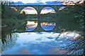
10
Victoria Viaduct crossing the River Wear
Victoria Viaduct. Built by the Durham Junction Railway and opened in 1838 to take coal from the Houghton-le-Spring area to the Tyne. As the railways expanded the viaduct became part of the main line from Darlington to Newcastle, before being relegated to a secondary route when the main line took the new route via Durham and Team Valley in 1872. By the 1980s the route was little used except when work on the main line required diversions, finally closing in 1991. Though the track is lifted the line retains a ‘mothballed’ status so has not been severed or built on, and is frequently proposed for reopening either as a heavy rail route or part of the Tyne and Wear Metro.
Image: © David Robinson
Taken: 14 Mar 2023
0.20 miles