IMAGES TAKEN NEAR TO
School Avenue, HOUGHTON LE SPRING, DH4 6SA
Introduction
This page details the photographs taken nearby to School Avenue, DH4 6SA by members of the Geograph project.
The Geograph project started in 2005 with the aim of publishing, organising and preserving representative images for every square kilometre of Great Britain, Ireland and the Isle of Man.

There are currently over 7.5m images from over14,400 individuals and you can help contribute to the project by visiting https://www.geograph.org.uk
Image Map (Loading...)


Getting Data...Please wait
Leaflet Map data © OpenStreetMap
Images are licensed for reuse under creativecommons.org/licenses/by-sa/2.0
Notes
- Clicking on the map will re-center to the selected point.
- The higher the marker number, the further away the image location is from the centre of the postcode.
Image Listing (23 Images Found)
Images are licensed for reuse under creativecommons.org/licenses/by-sa/2.0
Image
Details
Distance
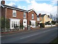
1
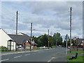
School Avenue, West Rainton
School Avenue in the village of West Rainton, County Durham.
Image: © Malc McDonald
Taken: 28 Aug 2011
0.05 miles
2
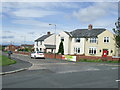
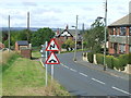
Prospect View, West Rainton
The road name signs say "School Avenue" - that is the road running from left to right across the lower part of the image. Prospect View is a side turning off School Avenue, in West Rainton.
Image: © Malc McDonald
Taken: 28 Aug 2011
0.06 miles
3
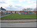
Playground, School Avenue, West Rainton
Image: © Oliver Dixon
Taken: 2 Mar 2007
0.08 miles
5
Station Road, West Rainton
Two fine Edwardian villas - Linden House to the left, Cathedral House to the right. Needless to say, the nearby station (Leamside) on the Leamside Line has long since ceased to be.
Image: © Oliver Dixon
Taken: 2 Mar 2007
0.13 miles
6
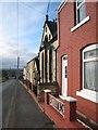
Station Road, West Rainton
This terrace includes a converted chapel. Needless to say, the nearby station (Leamside) on the Leamside Line has long since ceased to be.
Image: © Oliver Dixon
Taken: 2 Mar 2007
0.15 miles
7
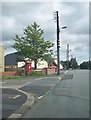
Station Road, Rainton Gate
Heading north west.
Image: © JThomas
Taken: 28 May 2015
0.15 miles
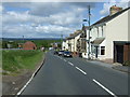
8
Station Road, West Rainton
Station Road in West Rainton leads downhill to the site of Leamside railway station, which closed in 1953. The station was behind the buildings where trees have now grown and matured. In the background, the concrete bridge carries a country lane over the A1(M) trunk road.
Image: © Malc McDonald
Taken: 28 Aug 2011
0.17 miles
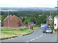
9
Station Road, West Rainton
Road signs warn of a double bend in the road, and a hump-backed bridge which carries the road over a railway line. Originally the road had continued straight ahead, with a level crossing across the railway.
The railway line is now disused.
Image: © Malc McDonald
Taken: 28 Aug 2011
0.18 miles
10
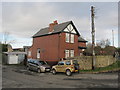
Former Leamside Stationmaster's house
Leamside was once a station on the East Coast Main Line, see Image for history.
Image: © David Hawgood
Taken: 12 Jan 2020
0.19 miles