IMAGES TAKEN NEAR TO
The Dene, HOUGHTON LE SPRING, DH4 6PR
Introduction
This page details the photographs taken nearby to The Dene, DH4 6PR by members of the Geograph project.
The Geograph project started in 2005 with the aim of publishing, organising and preserving representative images for every square kilometre of Great Britain, Ireland and the Isle of Man.

There are currently over 7.5m images from over14,400 individuals and you can help contribute to the project by visiting https://www.geograph.org.uk
Image Map
Images are licensed for reuse under creativecommons.org/licenses/by-sa/2.0
Notes
- Clicking on the map will re-center to the selected point.
- The higher the marker number, the further away the image location is from the centre of the postcode.
Image Listing (26 Images Found)
Images are licensed for reuse under creativecommons.org/licenses/by-sa/2.0
Image
Details
Distance
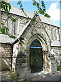
2
The Parish Church of St Mary the Virgin West Rainton, Doorway
Image: © Alexander P Kapp
Taken: 23 May 2011
0.04 miles
3
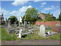
The Parish Church of St Mary the Virgin West Rainton, Graveyard
Image: © Alexander P Kapp
Taken: 23 May 2011
0.05 miles
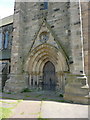
4
The Parish Church of St Mary the Virgin West Rainton, Porch
Image: © Alexander P Kapp
Taken: 23 May 2011
0.05 miles
6
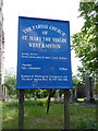
The Parish Church of St Mary the Virgin West Rainton, Sign
Image: © Alexander P Kapp
Taken: 23 May 2011
0.05 miles
7

The Parish Church of St Mary the Virgin, West Rainton
Image: © Alexander P Kapp
Taken: 23 May 2011
0.05 miles
8
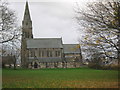
The Parish Church of St Mary the Virgin West Rainton
Image: © Peter Robinson
Taken: 9 Nov 2010
0.05 miles
9
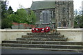
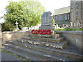
War Memorial, West Rainton
In front of St Mary the Virgin Church.
Image: © JThomas
Taken: 28 May 2015
0.05 miles
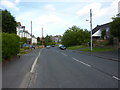
10

Benridge Bank, West Rainton
Looking north, with St Mary's church on the left. This part of the village is mainly 19th century or older. West Rainton dates back to mediaeval times, although it would have been just a small agricultural settlement until the coming of the pits in the 19th century.
Image: © Robert Graham
Taken: 3 Jul 2013
0.05 miles