IMAGES TAKEN NEAR TO
Chilton Avenue, HOUGHTON LE SPRING, DH4 6JZ
Introduction
This page details the photographs taken nearby to Chilton Avenue, DH4 6JZ by members of the Geograph project.
The Geograph project started in 2005 with the aim of publishing, organising and preserving representative images for every square kilometre of Great Britain, Ireland and the Isle of Man.

There are currently over 7.5m images from over14,400 individuals and you can help contribute to the project by visiting https://www.geograph.org.uk
Image Map
Images are licensed for reuse under creativecommons.org/licenses/by-sa/2.0
Notes
- Clicking on the map will re-center to the selected point.
- The higher the marker number, the further away the image location is from the centre of the postcode.
Image Listing (16 Images Found)
Images are licensed for reuse under creativecommons.org/licenses/by-sa/2.0
Image
Details
Distance
1
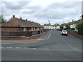
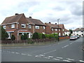
Acacia Avenue, Fencehouses
Bungalows and semi-detached houses in Fencehouses, near Houghton-le-Spring.
Image: © Malc McDonald
Taken: 29 Aug 2011
0.10 miles
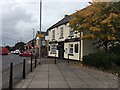
2
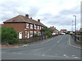
Brancepeth Avenue, Fencehouses
Housing in Fencehouses, near Houghton-le-Spring. Although they look like houses, a closer look shows that each one has two front doors. This suggests that they may be flats.
Image: © Malc McDonald
Taken: 29 Aug 2011
0.12 miles
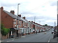
5
Acacia Avenue, Fencehouses
Houses in Acacia Avenue, Fencehouses.
Image: © Malc McDonald
Taken: 29 Aug 2011
0.18 miles
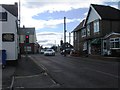
7
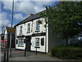
Naz Haven, Houghton-le-Spring
Tandoori restaurant on Front Street.
Image: © JThomas
Taken: 28 May 2015
0.19 miles
9
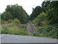
Disused railway at Fencehouses
The railway through Fencehouses lost its regular passenger trains in the 1960s. The line remained in use, both for freight trains and occasionally for diverted passenger trains on days when the main line through Durham and Chester-le-Street was closed for engineering work. The line became disused in around 1992.
Although no maintenance work is carried out, this railway line is still owned by Network Rail, and is being retained in case there is a need to bring it back into use in future. It would clearly need considerable work to restore the line to a useable state. At this location, the tracks are interrupted as tarmac has been laid across the site of a level crossing.
Image: © Malc McDonald
Taken: 29 Aug 2011
0.21 miles
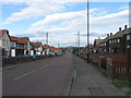
10
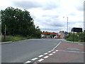
Site of level crossing, Fencehouses
The railway through Fencehouses lost its regular passenger trains in the 1960s. The line remained in use, both for freight trains and occasionally for diverted passenger trains on days when the main line through Durham and Chester-le-Street was closed for engineering work. The line became disused in around 1992.
Although no maintenance work was carried out, this railway line was still owned by Network Rail. When this image was taken, it was being retained in case there was a need to bring it back into use in future. Although much of the track was atill intact when this image was taken, here at Fencehouses it had already been covered over with tarmac at the site of a level crossing. The rest of the track was lifted about a year after this image was taken.
The railway route is also the border between Tyne & Wear (this side of the crossing) and County Durham (on the far side). The blue sign just beyond the crossing is the sign for County Durham.
Image: © Malc McDonald
Taken: 29 Aug 2011
0.21 miles