IMAGES TAKEN NEAR TO
Castlefields, HOUGHTON LE SPRING, DH4 6HJ
Introduction
This page details the photographs taken nearby to Castlefields, DH4 6HJ by members of the Geograph project.
The Geograph project started in 2005 with the aim of publishing, organising and preserving representative images for every square kilometre of Great Britain, Ireland and the Isle of Man.

There are currently over 7.5m images from over14,400 individuals and you can help contribute to the project by visiting https://www.geograph.org.uk
Image Map
Images are licensed for reuse under creativecommons.org/licenses/by-sa/2.0
Notes
- Clicking on the map will re-center to the selected point.
- The higher the marker number, the further away the image location is from the centre of the postcode.
Image Listing (11 Images Found)
Images are licensed for reuse under creativecommons.org/licenses/by-sa/2.0
Image
Details
Distance
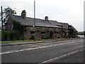
1

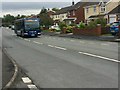
A1052 entering Bournmoor
Bournmoor is a village on County Durham close to its boundary with Sunderland. The blue and yellow road sign is in the style used in the county for place name road signage for some years.
Image: © Trevor Littlewood
Taken: 23 Mar 2018
0.08 miles
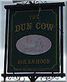
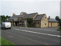
5
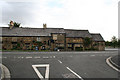
The Dun Cow
The Dun Cow Public house near Houghton Gate
Image: © Colin Keightley
Taken: 27 Aug 2005
0.10 miles
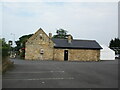
8
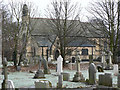
The Church of St. Barnabas
Built in 1867-1868, the church is in the village of Bournmoor in County Durham.
Photographed on a cold and frosty morning in late January 2006
Image: © Chris Tweedy
Taken: 30 Jan 2006
0.21 miles