IMAGES TAKEN NEAR TO
New Herrington, HOUGHTON LE SPRING, DH4 4LR
Introduction
This page details the photographs taken nearby to DH4 4LR by members of the Geograph project.
The Geograph project started in 2005 with the aim of publishing, organising and preserving representative images for every square kilometre of Great Britain, Ireland and the Isle of Man.

There are currently over 7.5m images from over14,400 individuals and you can help contribute to the project by visiting https://www.geograph.org.uk
Image Map
Images are licensed for reuse under creativecommons.org/licenses/by-sa/2.0
Notes
- Clicking on the map will re-center to the selected point.
- The higher the marker number, the further away the image location is from the centre of the postcode.
Image Listing (33 Images Found)
Images are licensed for reuse under creativecommons.org/licenses/by-sa/2.0
Image
Details
Distance
1
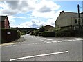
Kirkside, New Herrington
Short road leading to a small housing estate off St Aidan's Terrace. The church of that name once stood on the plot on the left here, possibly accounting for the name. There is a view of the wooded slopes of Herrington Hill behind.
Image: © Robert Graham
Taken: 15 Aug 2023
0.03 miles
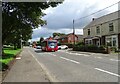
2
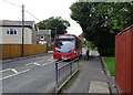
Bus on the main street, New Herrington
A No 35 bus going west along the B1286 through the village. This service comes from Boldon, via Sunderland town centre, to Low Moorsley.
Image: © Robert Graham
Taken: 15 Aug 2023
0.04 miles
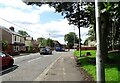
3
Bus on St Aidan's Terrace, New Herrington
Go North East service No 35 coming west along the B1286. This service runs from Boldon to Low Moorsley via Sunderland.
Image: © Robert Graham
Taken: 15 Aug 2023
0.05 miles
4
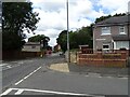
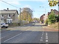
St Aidan's Road looking west
This is the B1286, the main road through this former mining village. Fletcher Crescent on the right runs parallel to the main road on the north. It was probably built as council housing for the miners after WWII, or possibly a bit earlier.
Image: © Robert Graham
Taken: 15 Aug 2023
0.06 miles
5
No 35 bus in New Herrington
No 35 Go North East service heading eastwards to Boldon, via Sunderland city centre. Travelling along the B1286, the main road through the village.
Image: © Robert Graham
Taken: 15 Aug 2023
0.06 miles
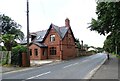
6
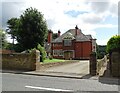
Former vicarage at St Aidan's Terrace, New Herrington
The church of St Aidan's has sadly been demolished, but the vicarage still remains. They were both designed by H Morton of South Shields. The house was built in 1888, a couple of years after the church. Now a private house and somewhat modified but not greatly.
Image: © Robert Graham
Taken: 15 Aug 2023
0.08 miles
7
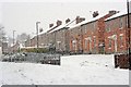
Housing Backing onto Fletcher Crescent
Image: © Mick Garratt
Taken: 23 Feb 2013
0.09 miles
8
St Aidan's Terrace, New Herrington
The B1286. There is a small shop on the right.
Image: © Oliver Dixon
Taken: 15 Nov 2016
0.09 miles
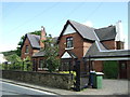
9
Sexton House, New Herrington
This Victorian house is on St Aidan's Terrace, and is beside the site of St Aidan's church, now demolished. It was built in 1891 presumably for the sexton of the graveyard.
Image: © Robert Graham
Taken: 15 Aug 2023
0.10 miles
10
Houses on St Aidan's Terrace, New Herrington
Image: © JThomas
Taken: 28 May 2015
0.11 miles