IMAGES TAKEN NEAR TO
Lambton Park, CHESTER LE STREET, DH3 4PH
Introduction
This page details the photographs taken nearby to DH3 4PH by members of the Geograph project.
The Geograph project started in 2005 with the aim of publishing, organising and preserving representative images for every square kilometre of Great Britain, Ireland and the Isle of Man.

There are currently over 7.5m images from over14,400 individuals and you can help contribute to the project by visiting https://www.geograph.org.uk
Image Map
Images are licensed for reuse under creativecommons.org/licenses/by-sa/2.0
Notes
- Clicking on the map will re-center to the selected point.
- The higher the marker number, the further away the image location is from the centre of the postcode.
Image Listing (7 Images Found)
Images are licensed for reuse under creativecommons.org/licenses/by-sa/2.0
Image
Details
Distance
1
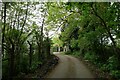
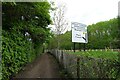
Side entrance to Biddick Hall
Part of the Lambton Estate
Image: © Tim Heaton
Taken: 18 May 2023
0.04 miles
2
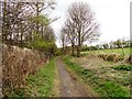
Path alongside Biddick Gill Wood
This is on the eastern edge of the Lambton estate south of Washington.
Image: © Robert Graham
Taken: 24 Apr 2013
0.14 miles
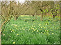
5

Trees in Biddick Woods
These woods surround Biddick Hall, on the eastern edge of the huge Lambton estate near Washington in Co Durham.
Image: © Robert Graham
Taken: 24 Apr 2013
0.22 miles
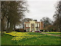
6
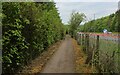
Approaching the A182
The Weardale Way heading towards the outskirts of Washington
Image: © Tim Heaton
Taken: 18 May 2023
0.23 miles
7
Weardale Way beside the A182
The long distance footpath has been granted a segregated channel to guide its trail back to the River Wear at Chartershaugh Bridge
Image: © Chris Heaton
Taken: 18 May 2023
0.23 miles