IMAGES TAKEN NEAR TO
Castle Dene, CHESTER LE STREET, DH3 4EY
Introduction
This page details the photographs taken nearby to DH3 4EY by members of the Geograph project.
The Geograph project started in 2005 with the aim of publishing, organising and preserving representative images for every square kilometre of Great Britain, Ireland and the Isle of Man.

There are currently over 7.5m images from over14,400 individuals and you can help contribute to the project by visiting https://www.geograph.org.uk
Image Map
Images are licensed for reuse under creativecommons.org/licenses/by-sa/2.0
Notes
- Clicking on the map will re-center to the selected point.
- The higher the marker number, the further away the image location is from the centre of the postcode.
Image Listing (12 Images Found)
Images are licensed for reuse under creativecommons.org/licenses/by-sa/2.0
Image
Details
Distance
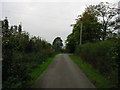
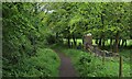
5
Lane to Lumley village.
This lane links Lumley Park woods and Lumley village. A shortcut between the Dower House and 'Back Lane'.
Image: © Ann Hodgson
Taken: 28 Dec 2001
0.13 miles
6
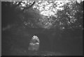
Waggonway crossing Lumley Park Burn, 1968
This old bridge led to the Whitehouse coal pit (Lumley 9th pit), and would only have been used for about 14 years for coal traffic, but now carries footpath 050/24/01 and an arm of the Weardale Way.
Image: © Derek Harper
Taken: Unknown
0.16 miles
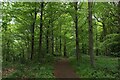
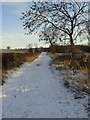
8
Weardale Way entering Lumley Park Wood
Image: © Chris Heaton
Taken: 18 May 2023
0.18 miles