IMAGES TAKEN NEAR TO
Plawsworth, CHESTER LE STREET, DH3 4EN
Introduction
This page details the photographs taken nearby to DH3 4EN by members of the Geograph project.
The Geograph project started in 2005 with the aim of publishing, organising and preserving representative images for every square kilometre of Great Britain, Ireland and the Isle of Man.

There are currently over 7.5m images from over14,400 individuals and you can help contribute to the project by visiting https://www.geograph.org.uk
Image Map
Images are licensed for reuse under creativecommons.org/licenses/by-sa/2.0
Notes
- Clicking on the map will re-center to the selected point.
- The higher the marker number, the further away the image location is from the centre of the postcode.
Image Listing (6 Images Found)
Images are licensed for reuse under creativecommons.org/licenses/by-sa/2.0
Image
Details
Distance
2
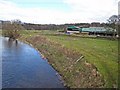
Low Cocken Farm and the River Wear
Low Cocken Farm is a popular horse-riding establishment.
Image: © Oliver Dixon
Taken: 2 Mar 2007
0.04 miles
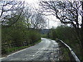
4
Cocken Road near Low Cocken Farm
Cocken Road, heading west and sweeping in an arc to the south, as seen from beside Low Cocken Farm.
Image: © Trevor Littlewood
Taken: 5 Jan 2018
0.08 miles
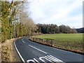
5
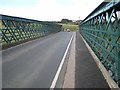
Cocken Bridge on the River Wear
The narrow lane leading down to this bridge is a popular rat run as it is the only crossing point of the River Wear on the long stretch between Durham and Chester-le-Street.
Image: © Oliver Dixon
Taken: 2 Mar 2007
0.08 miles
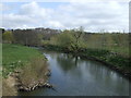
6
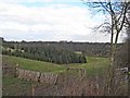
Wear Valley, Cocken
Looking down into the Wear Valley from Cocken Road. Low Cocken Farm Image can be seen in the right middle distance.
Image: © Oliver Dixon
Taken: 2 Mar 2007
0.17 miles