IMAGES TAKEN NEAR TO
Church Chare, CHESTER LE STREET, DH3 3QB
Introduction
This page details the photographs taken nearby to Church Chare, DH3 3QB by members of the Geograph project.
The Geograph project started in 2005 with the aim of publishing, organising and preserving representative images for every square kilometre of Great Britain, Ireland and the Isle of Man.

There are currently over 7.5m images from over14,400 individuals and you can help contribute to the project by visiting https://www.geograph.org.uk
Image Map
Images are licensed for reuse under creativecommons.org/licenses/by-sa/2.0
Notes
- Clicking on the map will re-center to the selected point.
- The higher the marker number, the further away the image location is from the centre of the postcode.
Image Listing (104 Images Found)
Images are licensed for reuse under creativecommons.org/licenses/by-sa/2.0
Image
Details
Distance
1
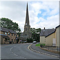
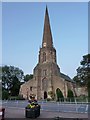
Chester-le-Street church spire
The 158ft/48m spire of the parish church of St Mary and St Cuthbert dates from 1409 and is the tallest in the Durham Palatinate. For more about the church, try https://en.wikipedia.org/wiki/St_Mary_and_St_Cuthbert,_Chester-le-Street .
Image: © John Sutton
Taken: 14 Jul 2021
0.02 miles
2
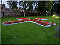
Parish Church of St Mary and St Cuthbert, Chester-le-Street, Graveyard/garden
Image: © Alexander P Kapp
Taken: 25 Aug 2011
0.03 miles
3
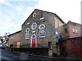
Bethal Chapel, Chester le Street
This URC chapel dates from 1814, although there is a date plaque for 1860 on the wall here, but that was the date of an alteration.
Image: © Robert Graham
Taken: 14 Oct 2019
0.03 miles
4
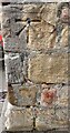
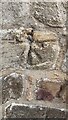
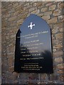
Benchmark on buttress on west face of St Mary and St Cuthbert Church
1GL bolt benchmark levelled at 21.879m above Newlyn Datum verified 1962. It was originally levelled at 73.439 feet above Liverpool Datum during the 1842-1845 Selby to Newcastle-upon-Tyne 1GL Survey. The surveyor's description was: 'No. 213. Bolt in North abutment of West face of Chester-le-Street Church tower ; 1.64 ft. above surface'
Image: © Roger Templeman
Taken: 11 Oct 2022
0.03 miles
5
Benchmark on tower porch of St Mary and St Cuthbert Church
Ordnance Survey 1GL bolt benchmark, possibly the benchmark shown as levelled at 72.3 feet above Liverpool on the 1888-1913 6" Map, possibly replaced by Image
Image: © Roger Templeman
Taken: 11 Oct 2022
0.03 miles
6
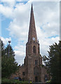
Chester-le-Street Parish Church
St Mary and St Cuthbert Church, with a 48 metre spire.
Image: © Alison Stamp
Taken: 6 Aug 2005
0.04 miles
7
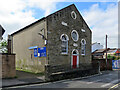
Chester-le-Street: Bethel United Reformed Church
The building, on Low Chare, was remodelled in 1860.
Image: © John Sutton
Taken: 14 Jul 2021
0.04 miles
8
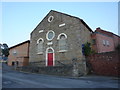
Bethel Church, Low Chare, Chester-le-Street
Image: © Alexander P Kapp
Taken: 25 Aug 2011
0.04 miles
9
Parish Church of St Mary and St Cuthbert, Chester-le-Street
http://www.maryandcuthbert.org.uk
Image: © Alexander P Kapp
Taken: 25 Aug 2011
0.04 miles
10
Parish Church of St Mary and St Cuthbert, Chester-le-Street, Sign
Image: © Alexander P Kapp
Taken: 25 Aug 2011
0.04 miles