IMAGES TAKEN NEAR TO
Hermitage Park, CHESTER LE STREET, DH3 3JZ
Introduction
This page details the photographs taken nearby to Hermitage Park, DH3 3JZ by members of the Geograph project.
The Geograph project started in 2005 with the aim of publishing, organising and preserving representative images for every square kilometre of Great Britain, Ireland and the Isle of Man.

There are currently over 7.5m images from over14,400 individuals and you can help contribute to the project by visiting https://www.geograph.org.uk
Image Map
Images are licensed for reuse under creativecommons.org/licenses/by-sa/2.0
Notes
- Clicking on the map will re-center to the selected point.
- The higher the marker number, the further away the image location is from the centre of the postcode.
Image Listing (13 Images Found)
Images are licensed for reuse under creativecommons.org/licenses/by-sa/2.0
Image
Details
Distance
1
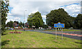
Grassed area adjacent to A167
The location is, clearly enough, beside the County Durham town of Chester-le-Street. The blue and yellow road sign is in a style commonly found in the county.
Image: © Trevor Littlewood
Taken: 18 Aug 2017
0.06 miles
2
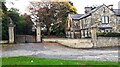
East Lodge at entrance to The Hermitage Estate
There is an Ordnance Survey benchmark Image on the right hand wall pier
Image: © Roger Templeman
Taken: 11 Oct 2022
0.07 miles
3
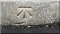
Benchmark on wall pier at entrance to The Hermitage Estate
Ordnance Survey cut mark benchmark levelled at 34.305m above Newlyn Datum verified 1964
Image: © Roger Templeman
Taken: 11 Oct 2022
0.07 miles
4
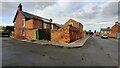
#11 The Parade, 'Hollycroft' with its rear outbuilding
There is an Ordnance Survey benchmark on the near corner, left hand face, of the outbuilding
Image: © Roger Templeman
Taken: 11 Oct 2022
0.15 miles
5
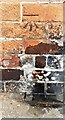
Benchmark on outbuilding at rear of #11 The Parade
Ordnance Survey cut mark benchmark levelled at 30.248m above Newlyn Datum verified 1964
Image: © Roger Templeman
Taken: 11 Oct 2022
0.15 miles
7
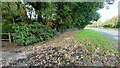
Verge beside northbound A167 near Chester Dene
Ordnance Survey documents indicate that a benchmark levelled at 33.674m above Newlyn Datum was verified in 1964 on the wall, now covered with ivy, on the left hand side of the verge
Image: © Roger Templeman
Taken: 11 Oct 2022
0.21 miles
8
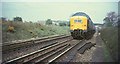
Deltic at Southburn Dene, 1968
Looking in the other direction from the spot where Image was taken, as the track runs through a shallow cutting. In the background, in Image, is the bridge carryig the road to The Hermitage, and houses on Carrowmore Road.
Image: © Derek Harper
Taken: 1 May 1968
0.23 miles
9
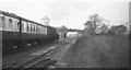
Flying Scotsman approaching Chester-le-Street, 1968
Taken just after Image, as the anniversary journey runs through the cutting shown in Image This shows the bridge more clearly, together with the terrace seen in Image Black and white image from a colour slide.
Image: © Derek Harper
Taken: 1 May 1968
0.23 miles
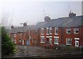
10
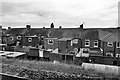
Terraced Houses on Melville Street
Looking down from the East Coast Main Line railway route.
Image: © David Dixon
Taken: 22 Mar 2016
0.24 miles