IMAGES TAKEN NEAR TO
Station Road, CHESTER LE STREET, DH3 3AB
Introduction
This page details the photographs taken nearby to Station Road, DH3 3AB by members of the Geograph project.
The Geograph project started in 2005 with the aim of publishing, organising and preserving representative images for every square kilometre of Great Britain, Ireland and the Isle of Man.

There are currently over 7.5m images from over14,400 individuals and you can help contribute to the project by visiting https://www.geograph.org.uk
Image Map
Images are licensed for reuse under creativecommons.org/licenses/by-sa/2.0
Notes
- Clicking on the map will re-center to the selected point.
- The higher the marker number, the further away the image location is from the centre of the postcode.
Image Listing (93 Images Found)
Images are licensed for reuse under creativecommons.org/licenses/by-sa/2.0
Image
Details
Distance
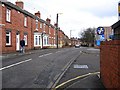
1
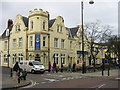
Lambton Arms Public House Chester-le-Street
Image: © rob bishop
Taken: 25 Feb 2006
0.01 miles
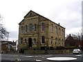
3
Queens Head, Chester-le-Street
Hostelry on Front Street, now heavily boarded up.
Image: © Chris Heaton
Taken: 18 May 2023
0.01 miles
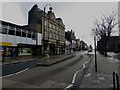
4
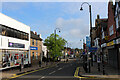
Front Street, Chester-le-Street
Main shopping area, in Chester-le-Street.
Image: © Chris Heaton
Taken: 17 May 2023
0.03 miles
6
Front Street, Chester-le-Street
The main shopping street in the centre of Chester-le-Street.
Image: © Graham Robson
Taken: 17 Mar 2018
0.06 miles
7
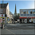
Chester-le-Street: Front Street and the parish church
A view towards the church of St Mary and St Cuthbert on a bright September morning.
Image: © John Sutton
Taken: 18 Sep 2013
0.07 miles
8
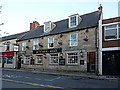
Butchers Arms, Middle Chare, Chester-le-Street
Image: © Alexander P Kapp
Taken: 25 Aug 2011
0.07 miles
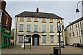
9
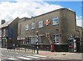
Chester-le Street Post Office
One of only two bearing the Royal Emblem of King Edward VIII
see http://en.wikipedia.org/wiki/Chester-le-Street
Image: © Peter Robinson
Taken: 11 Aug 2013
0.07 miles
10
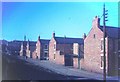
Back to backs, Chester-le-Street, 1967
In the foreground is Wesley Terrace. These terraces, which ran across to Foundry Lane, have since been demolished and the area is now occupied by a car park and a branch of Wilkinson. The building on the left in front of the later housing and beside the station still exists and houses a roofing company. On the left is a bank running up to Station Road.
Image: © Derek Harper
Taken: Unknown
0.07 miles