IMAGES TAKEN NEAR TO
Barnstones, CHESTER LE STREET, DH2 3UZ
Introduction
This page details the photographs taken nearby to Barnstones, DH2 3UZ by members of the Geograph project.
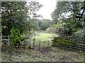
The Geograph project started in 2005 with the aim of publishing, organising and preserving representative images for every square kilometre of Great Britain, Ireland and the Isle of Man.

There are currently over 7.5m images from over14,400 individuals and you can help contribute to the project by visiting https://www.geograph.org.uk
Image Map
Images are licensed for reuse under creativecommons.org/licenses/by-sa/2.0
Notes
- Clicking on the map will re-center to the selected point.
- The higher the marker number, the further away the image location is from the centre of the postcode.
Image Listing (35 Images Found)
Images are licensed for reuse under creativecommons.org/licenses/by-sa/2.0
Image
Details
Distance
1
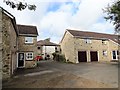
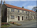
East Farm, Plawsworth
Plawsworth originated as a farming community, and still has a rural look. However, all the former farm buildings, such as these ones here, have now been converted to residential.
Image: © Robert Graham
Taken: 23 Sep 2019
0.02 miles
2
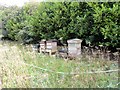
Beehives at Plawsworth
A rather unusual sight in the Durham countryside. These were in a paddock behind East Farm.
Image: © Robert Graham
Taken: 23 Sep 2019
0.04 miles
3
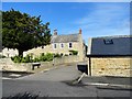
Entrance to Plawsworth Farm
These are probably mid 19 century former farm buildings and are typical of Plawsworth villages rural origins. I don't think this is a working farm any longer however. The village appears to be all residential now.
Image: © Robert Graham
Taken: 23 Sep 2019
0.07 miles
4
Field path south of East Farm
This path lead through the fields behind East Farm at Plawsworth to Mill Lane at Plawsworth Gate. It is just a short distance, but didn't seem as if it was used much.
Image: © Robert Graham
Taken: 23 Sep 2019
0.07 miles
5
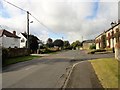
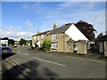
View along the village street at Plawsworth
Looking west. Plawsworth has always been a farming community, unlike most villages in the area which were much altered by coalmining. There were no pits at Plawsworth.
Image: © Robert Graham
Taken: 23 Sep 2019
0.08 miles
8
West side of Plawsworth
This is the west end of the village street, Wheatleywell Lane. The slip road onto the A167 can be seen behind the houses.
Image: © Robert Graham
Taken: 23 Sep 2019
0.09 miles
9
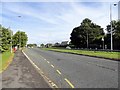
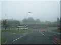
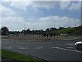
The Great North Road at Plawsworth
This was originally the A1, The Great North Road. It was replaced as the main northern route by the construction of the Durham Motorway, the A1M, in 1970. View is looking north with the village on the right.
Image: © Robert Graham
Taken: 23 Sep 2019
0.09 miles