IMAGES TAKEN NEAR TO
The Dene, CHESTER LE STREET, DH2 3TB
Introduction
This page details the photographs taken nearby to The Dene, DH2 3TB by members of the Geograph project.
The Geograph project started in 2005 with the aim of publishing, organising and preserving representative images for every square kilometre of Great Britain, Ireland and the Isle of Man.

There are currently over 7.5m images from over14,400 individuals and you can help contribute to the project by visiting https://www.geograph.org.uk
Image Map
Images are licensed for reuse under creativecommons.org/licenses/by-sa/2.0
Notes
- Clicking on the map will re-center to the selected point.
- The higher the marker number, the further away the image location is from the centre of the postcode.
Image Listing (12 Images Found)
Images are licensed for reuse under creativecommons.org/licenses/by-sa/2.0
Image
Details
Distance
2

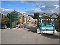
God's Kitchen, Chester Moor
God's kitchen is a restaurant on the site of a former church - adjacent to it (on the left in the picture) is a model shop, 'Model Active' - in what was presumably the church hall. They front on to the A167 (old A1) at Chester Moor.
Image: © Brian Abbott
Taken: 2 Nov 2006
0.16 miles

5
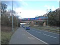
Train passing over the A167
The East Coast Main Line passes over the A167 Chester-le-Street to Durham road. The broad footway serves as a cycleway.
Image: © Oliver Dixon
Taken: 2 Mar 2007
0.20 miles
6

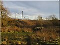
Railway bridge over the A167
The A167 Durham to Chester-le-Street road goes through two tight bends to pass under the East Coast Main Line.
Image: © Oliver Dixon
Taken: 2 Mar 2007
0.20 miles
7
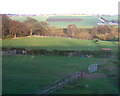
Chester Moor Nature Reserve
East Coast Mainline railway passing through Chester Moor Nature Reserve
Image: © Dylan Chester
Taken: 15 Feb 2023
0.22 miles

9
Southburn Dene railway viaduct, 1968
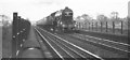
A service crosses the viaduct south of Chester-le-Street, spanning Southburn Dene just north of the railway bridge shown in http://www.geograph.org.uk/search.php?i=39378269 . That looks like a Sulzer type 4 locomotive. The 8-arched viaduct dates from 1868 http://www.imagesofengland.org.uk/Details/Default.aspx?id=109372&mode=adv ; the stone plinths can be seen below. The dene is more wooded these days. The South Burn joins the Wear less than a kilometre away, to the left.
Image: © Derek Harper
Taken: 1 May 1968
0.25 miles
10
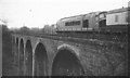
Flying Scotsman at Southburn Dene viaduct, 1968
The locomotive, number 4472, celebrates the 40th anniversary of its first non-stop run from Kings Cross to Edinburgh on 1st May 1928 by repeating the journey, after its rescue from the breaker's yard and restoration by Alan Pegler. Here it crosses the viaduct shown in Image On the right is a glimpse of Moor Cottage, a house beside the A167. Black and white image from a colour slide.
Image: © Derek Harper
Taken: 1 May 1968
0.25 miles