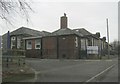
IMAGES TAKEN NEAR TO
Chester Moor, CHESTER LE STREET, DH2 3RX
Introduction
This page details the photographs taken nearby to DH2 3RX by members of the Geograph project.
The Geograph project started in 2005 with the aim of publishing, organising and preserving representative images for every square kilometre of Great Britain, Ireland and the Isle of Man.

There are currently over 7.5m images from over14,400 individuals and you can help contribute to the project by visiting https://www.geograph.org.uk
Image Map
Images are licensed for reuse under creativecommons.org/licenses/by-sa/2.0
Notes
- Clicking on the map will re-center to the selected point.
- The higher the marker number, the further away the image location is from the centre of the postcode.
Image Listing (7 Images Found)
Images are licensed for reuse under creativecommons.org/licenses/by-sa/2.0
Image
Details
Distance
1
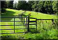
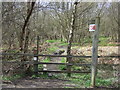
Public footpath alongside fence
The path is one of a number crossing land in the area north of Nettlesworth and close to Felledge Farm; the farm is on the other side of the right hand trees.
Image: © Trevor Littlewood
Taken: 18 Aug 2017
0.15 miles
2
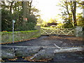
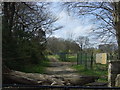
Footpath from Beanley Lane leading past Fell Edge Farm
Image: © P Glenwright
Taken: 12 Nov 2006
0.16 miles
3
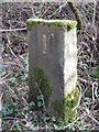
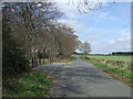
Old Boundary Marker on Waldridge Fell
Parish Boundary Marker on Waldridge Fell, on the south side of a footpath leaving Waldridge Lane. Waldridge parish. On the former boundary of Waldridge and Chester le Street parishes but now entirely in Waldridge parish.
Milestone Society National ID: DU_WALDR01pb
Image: © Mike Rayner
Taken: 27 Feb 2021
0.20 miles