IMAGES TAKEN NEAR TO
Plawsworth, CHESTER LE STREET, DH2 3NL
Introduction
This page details the photographs taken nearby to DH2 3NL by members of the Geograph project.
The Geograph project started in 2005 with the aim of publishing, organising and preserving representative images for every square kilometre of Great Britain, Ireland and the Isle of Man.

There are currently over 7.5m images from over14,400 individuals and you can help contribute to the project by visiting https://www.geograph.org.uk
Image Map
Images are licensed for reuse under creativecommons.org/licenses/by-sa/2.0
Notes
- Clicking on the map will re-center to the selected point.
- The higher the marker number, the further away the image location is from the centre of the postcode.
Image Listing (20 Images Found)
Images are licensed for reuse under creativecommons.org/licenses/by-sa/2.0
Image
Details
Distance
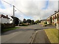
5
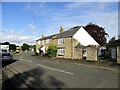
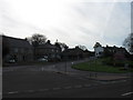
West side of Plawsworth
This is the west end of the village street, Wheatleywell Lane. The slip road onto the A167 can be seen behind the houses.
Image: © Robert Graham
Taken: 23 Sep 2019
0.18 miles
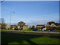
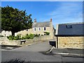
6
New development at Plawsworth Hall
The old farm here has been redeveloped as a residential complex. This is on the eastern side of the village.
Image: © Robert Graham
Taken: 23 Sep 2019
0.18 miles
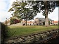
7
Entrance to Plawsworth Farm
These are probably mid 19 century former farm buildings and are typical of Plawsworth villages rural origins. I don't think this is a working farm any longer however. The village appears to be all residential now.
Image: © Robert Graham
Taken: 23 Sep 2019
0.18 miles
8
Houses at Plawsworth Hall
The former Plawsworth Hall Farm has been extensively redeveloped in recent years for residential use. This is on the east side of the little rural village of Plawsworth.
Image: © Robert Graham
Taken: 23 Sep 2019
0.19 miles
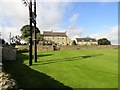
9
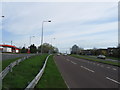
View along the village street at Plawsworth
Looking west. Plawsworth has always been a farming community, unlike most villages in the area which were much altered by coalmining. There were no pits at Plawsworth.
Image: © Robert Graham
Taken: 23 Sep 2019
0.19 miles
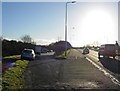
10
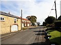
Old buildings at Plawsworth Farm
A view looking east along Wheatleywell Lane, the road through the village. The surrounding villages here are all ex-mining villages of the late 19 or early 20 centuries, but Plawsworth is older and of rural origins. These old former farm buildings or cottages are typical of the present village.
Image: © Robert Graham
Taken: 23 Sep 2019
0.20 miles