IMAGES TAKEN NEAR TO
Stone Row, CHESTER LE STREET, DH2 3NB
Introduction
This page details the photographs taken nearby to Stone Row, DH2 3NB by members of the Geograph project.
The Geograph project started in 2005 with the aim of publishing, organising and preserving representative images for every square kilometre of Great Britain, Ireland and the Isle of Man.

There are currently over 7.5m images from over14,400 individuals and you can help contribute to the project by visiting https://www.geograph.org.uk
Image Map
Images are licensed for reuse under creativecommons.org/licenses/by-sa/2.0
Notes
- Clicking on the map will re-center to the selected point.
- The higher the marker number, the further away the image location is from the centre of the postcode.
Image Listing (32 Images Found)
Images are licensed for reuse under creativecommons.org/licenses/by-sa/2.0
Image
Details
Distance
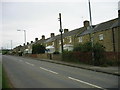
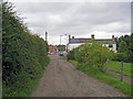
2
Looking along Stone Row, Grange Villa
This road forms the western edge of the village. The stone houses here date from the founding of the ex-mining village in the late C19.
Image: © Robert Graham
Taken: 12 Aug 2019
0.02 miles
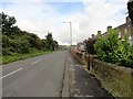
3
Bottom of Stone Row, Grange Villa
This is the south end of the street, where it joins Pelton Lane, the main street through the village. Stone Row was the first street to be built here, for the miners of West Pelton Colliery in the fourth quarter of the C19. In the early years of the C20, it was joined by further rows of miners houses, these being brick built.
Image: © Robert Graham
Taken: 12 Aug 2019
0.03 miles
4
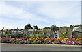
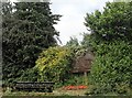
Roadside flower display at Grange Villa
A lovely display of colour in front of the allotments at Stone Row in this ex mining village.
Image: © Robert Graham
Taken: 16 Sep 2019
0.04 miles
5
Village sign, Grange Villa
This wooden carving is at the roadside on the southwest corner of the village. It has carvings of the typical things which would be going on in the allotments behind here, such as pigeons, rabbits, vegetables etc. Unfortunately, the hedge has rather overgrown it at the moment.
Image: © Robert Graham
Taken: 12 Aug 2019
0.05 miles
6
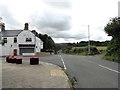
Road junction, Grange Villa
This is the junction of Pelton Lane, on the left, with Stone Row, at the SW corner of the village.
Image: © Robert Graham
Taken: 12 Aug 2019
0.05 miles
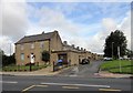
7
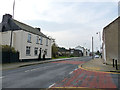
Grange Villa Working Men's Club
On Pelton Lane, the village main street. The club was once at the heart of all the mining villages in Co Durham, but many have shared the fate of village pubs and closed. Grange Villa's, happily, seems to be surviving.
Image: © Robert Graham
Taken: 12 Aug 2019
0.06 miles
9
Track into Grange Villa
Behind the photographer, the track leads to farm buildings at Twizell Dykes. The area is now open countryside, but not so long ago was busy with coal mine workings and waste tips.
Image: © Richard Dorrell
Taken: 26 Jul 2011
0.06 miles
10
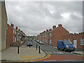
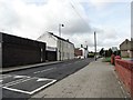
Queen Street, Grange Villa
Seen from its junction with Pelton Lane, this is one of several similar streets of small terraced houses in this rural ex-mining settlement.
Image: © Richard Dorrell
Taken: 26 Jul 2011
0.07 miles