IMAGES TAKEN NEAR TO
Southdowns, CHESTER LE STREET, DH2 3AH
Introduction
This page details the photographs taken nearby to Southdowns, DH2 3AH by members of the Geograph project.
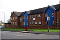
The Geograph project started in 2005 with the aim of publishing, organising and preserving representative images for every square kilometre of Great Britain, Ireland and the Isle of Man.

There are currently over 7.5m images from over14,400 individuals and you can help contribute to the project by visiting https://www.geograph.org.uk
Image Map (Loading...)


Getting Data...Please wait
Leaflet Map data © OpenStreetMap
Images are licensed for reuse under creativecommons.org/licenses/by-sa/2.0
Notes
- Clicking on the map will re-center to the selected point.
- The higher the marker number, the further away the image location is from the centre of the postcode.
Image Listing (38 Images Found)
Images are licensed for reuse under creativecommons.org/licenses/by-sa/2.0
Image
Details
Distance
2
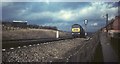
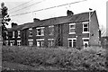
Train at Chester-le-Street, 1968
A service passes Earnest Terrace (right) heading south, south of Chester-le-Street station.
The little barns and the field on the left are now the site of modern sheltered housing in grounds.
Image: © Derek Harper
Taken: Unknown
0.07 miles
3
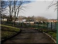
Newker Primary School, Chester-le-Street
A low rise primary school located of Waldridge Road in Chester-le-Street.
Image: © Graham Robson
Taken: 17 Mar 2018
0.07 miles
4
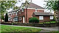
Houses on south side of Waldridge Road
There is an Ordnance Survey benchmark Image on the corner of the nearest house, left of a black downpipe
Image: © Roger Templeman
Taken: 11 Oct 2022
0.08 miles
5
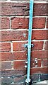
Benchmark on #29 Waldridge Road
Ordnance Survey cut mark benchmark levelled at 55.385m above Newlyn Datum verified in 1962
Image: © Roger Templeman
Taken: 11 Oct 2022
0.09 miles
6
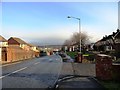
Looking east down Waldridge Road
This road rises steadily uphill from the south end of Chester-le-Street town centre, to the west. The railway bridge can be seen at the bottom of the hill.
Image: © Robert Graham
Taken: 28 Nov 2012
0.10 miles
8
Mini-roundabout Waldridge Rd/South Approach
Image: © Roger Smith
Taken: 9 Oct 2008
0.10 miles
9
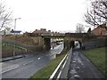
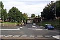
Railway bridge crossing Waldridge Road, Chester-le-Street
The East Cost Mainline crossing over Waldridge Road to the south of the railway station in Chester-le-Street.
Image: © Graham Robson
Taken: 17 Mar 2018
0.11 miles
10
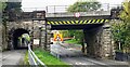
Bridge ECM5 219 taking East Coast Main Line over West Lane
Ordnance Survey documents indicate that a rivet benchmark levelled at 32.803m above Newlyn Datum was verified in 1962 on the bridge wall, at its far end, on the right hand side of the road
Image: © Roger Templeman
Taken: 11 Oct 2022
0.11 miles