IMAGES TAKEN NEAR TO
William Street, CHESTER LE STREET, DH2 2SF
Introduction
This page details the photographs taken nearby to William Street, DH2 2SF by members of the Geograph project.
The Geograph project started in 2005 with the aim of publishing, organising and preserving representative images for every square kilometre of Great Britain, Ireland and the Isle of Man.

There are currently over 7.5m images from over14,400 individuals and you can help contribute to the project by visiting https://www.geograph.org.uk
Image Map
Images are licensed for reuse under creativecommons.org/licenses/by-sa/2.0
Notes
- Clicking on the map will re-center to the selected point.
- The higher the marker number, the further away the image location is from the centre of the postcode.
Image Listing (12 Images Found)
Images are licensed for reuse under creativecommons.org/licenses/by-sa/2.0
Image
Details
Distance
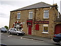
1
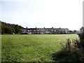
William Street, Newfield
This terraced row is about all that remains of the old late 19th century mining village of Newfield, apart from a few building on Front Street. This terrace was once one of a whole series of streets of miners cottages.
Image: © Robert Graham
Taken: 14 Oct 2019
0.00 miles
2
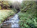
The Twizell Burn
Flowing through Grange Plantation at Pelton Fell. Flowing strongly after recent heavy rain.
Image: © Robert Graham
Taken: 14 Oct 2019
0.08 miles
3
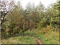
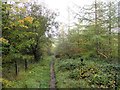
Path through Grange Plantation
This path leads from Newfield to Pelton Fell and zigzags down the steep slope of the little valley of the Twizell Burn.
Image: © Robert Graham
Taken: 14 Oct 2019
0.10 miles
4
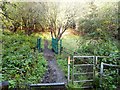
Footbridge over the Twizell Burn
Carrying the path from Newfield to Grange Terrace in Pelton Fell through Grange Plantation.
Image: © Robert Graham
Taken: 14 Oct 2019
0.10 miles
5

New housing development in Pelton
The development is named Roseberry Park and is on an apparent green field site on the north side of Front Street in the part of Pelton known as Newfield. Kensington Way is the road entering the estate.
Image: © Trevor Littlewood
Taken: 8 Mar 2017
0.12 miles
6
Footpath on the south side of the Twizell Byrn
Through Grange Plantation at Pelton Fell. This is the path leading south across the steep little valley of the burn from Newfield.
Image: © Robert Graham
Taken: 14 Oct 2019
0.13 miles
7
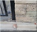
Ordnance Survey Cut Mark
This OS cut mark can be found on the SW face of Newfield House on Front Street. It marks a point 95.277m above mean sea level.
Image: © Adrian Dust
Taken: 20 Sep 2018
0.15 miles
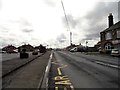
8
Newfield Front Street
Looking east along the village main street. Newfield is a late 19th century mining village, with the pits long gone of course.
Image: © Robert Graham
Taken: 14 Oct 2019
0.17 miles
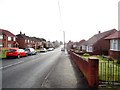
10
View down Newfield Road
In Pelton Lane Ends village. Looking east from the junction with Pelton Lane, with the Newfield Inn on the right. The car park used to be the site of Roseberry Comprehensive, which was closed in 2014 and demolished shortly afterwards.
Image: © Robert Graham
Taken: 12 Aug 2019
0.23 miles