IMAGES TAKEN NEAR TO
Elmway, CHESTER LE STREET, DH2 2LG
Introduction
This page details the photographs taken nearby to Elmway, DH2 2LG by members of the Geograph project.
The Geograph project started in 2005 with the aim of publishing, organising and preserving representative images for every square kilometre of Great Britain, Ireland and the Isle of Man.

There are currently over 7.5m images from over14,400 individuals and you can help contribute to the project by visiting https://www.geograph.org.uk
Image Map
Images are licensed for reuse under creativecommons.org/licenses/by-sa/2.0
Notes
- Clicking on the map will re-center to the selected point.
- The higher the marker number, the further away the image location is from the centre of the postcode.
Image Listing (10 Images Found)
Images are licensed for reuse under creativecommons.org/licenses/by-sa/2.0
Image
Details
Distance
1
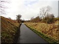
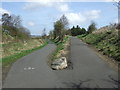
Looking along to the road bridge
View west along the old railway path at South Pelaw towards the bridge which carries the road to Pelton.
Image: © Robert Graham
Taken: 6 Feb 2013
0.11 miles
3
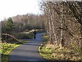
Consett and Sunderland Railway Path at South Pelaw
The Consett and Sunderland Railway Path forms part of National Cycle Network route 7 and the famous C2C Cycle Route. This section is tarmac.
Image: © Oliver Dixon
Taken: 8 Jan 2014
0.11 miles
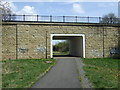
4
Bridge over the Consett and Sunderland Railway Path
The bridge carrying Pelton Lane over the Consett and Sunderland Railway Path (part of the C2C cycle route) has been rebuilt in recent years. The date on the bridge is 2001.
Image: © Oliver Dixon
Taken: 29 Aug 2016
0.13 miles
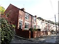
6
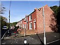
East end of Glen Terrace
Rather distinctive row of terraced houses built in Edwardian times. It stands on Pelton Fell Road on the western edge of Chester le Street town centre.
Image: © Robert Graham
Taken: 14 Oct 2019
0.22 miles
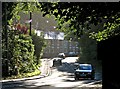
7
Glen Terrace
Glen Terrace, in Chester-Le-Street, seen from the west along the B6313.
Image: © Trevor Littlewood
Taken: 7 Sep 2019
0.23 miles
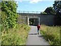
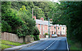
8
Glen Terrace in September
A view down Pelton Fell Road, against the light on a bright September morning. The shadowed parapet of Whitehill Bridge is on the right of the picture.
Image: © John Sutton
Taken: 18 Sep 2013
0.23 miles
9
West end of Glen Terrace
This street stands on Pelton Fell Road, which follows the Cong Burn through the wooded ravine of Stella Gill into Chester le Street town Centre. It is a rather strange spot for a row of terraced houses, but there was an ironworks here in late Victorian times, and this may have been for the workers. Built in the early 20th century, before the First World War.
Image: © Robert Graham
Taken: 14 Oct 2019
0.23 miles
10
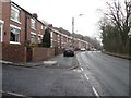
Terraced houses, Pelton Fell Road
A terrace of houses sitting on the northern side of Pelton Fell Road between Pelton Fell and Chester-le-Street.
Image: © Graham Robson
Taken: 17 Mar 2018
0.23 miles