IMAGES TAKEN NEAR TO
Victoria Terrace, CHESTER LE STREET, DH2 1PZ
Introduction
This page details the photographs taken nearby to Victoria Terrace, DH2 1PZ by members of the Geograph project.
The Geograph project started in 2005 with the aim of publishing, organising and preserving representative images for every square kilometre of Great Britain, Ireland and the Isle of Man.

There are currently over 7.5m images from over14,400 individuals and you can help contribute to the project by visiting https://www.geograph.org.uk
Image Map
Images are licensed for reuse under creativecommons.org/licenses/by-sa/2.0
Notes
- Clicking on the map will re-center to the selected point.
- The higher the marker number, the further away the image location is from the centre of the postcode.
Image Listing (6 Images Found)
Images are licensed for reuse under creativecommons.org/licenses/by-sa/2.0
Image
Details
Distance
1
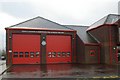
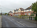
High Handenhold fire station
High Handenhold fire station, Pelton, Chester-Le-Street, County Durham, showing the appliance bays, in contrast to the more distant shot in Image
Image: © Kevin Hale
Taken: 26 Nov 2006
0.05 miles
2
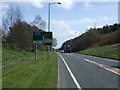
A693 heading east
Towards Chester-le-Street.
Image: © JThomas
Taken: 2 May 2013
0.06 miles
4
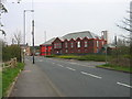
Fire Station High Handenhold
High Handenhold Fire Station was opened on 9th October 1997 and provides fire and rescue cover for approximately 89 sq km (34.5 sq m) bordering with Tyne and Wear Metropolitan Fire Brigade.
Image: © Les Hull
Taken: 24 Apr 2006
0.12 miles
6
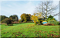
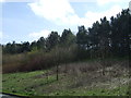
Open ground at High Handenhold
An area of grassed, landscaped ground with deciduous trees beside the small County Durham settlement of High Handenhold. The blue and yellow naming plate is in a style widely in use in the county.
Image: © Trevor Littlewood
Taken: 9 Nov 2019
0.20 miles