IMAGES TAKEN NEAR TO
Prebend Row, CHESTER LE STREET, DH2 1NH
Introduction
This page details the photographs taken nearby to Prebend Row, DH2 1NH by members of the Geograph project.
The Geograph project started in 2005 with the aim of publishing, organising and preserving representative images for every square kilometre of Great Britain, Ireland and the Isle of Man.

There are currently over 7.5m images from over14,400 individuals and you can help contribute to the project by visiting https://www.geograph.org.uk
Image Map
Images are licensed for reuse under creativecommons.org/licenses/by-sa/2.0
Notes
- Clicking on the map will re-center to the selected point.
- The higher the marker number, the further away the image location is from the centre of the postcode.
Image Listing (25 Images Found)
Images are licensed for reuse under creativecommons.org/licenses/by-sa/2.0
Image
Details
Distance
1
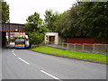
Bridge carrying CtoC cycle path and underpass
the bus is the 809 to Chester le Street
Image: © P Glenwright
Taken: 18 Sep 2006
0.01 miles

3
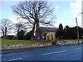
Holy Trinity Church, Pelton
Dates from 1841, obviously from the time when the village expanded with the increase in coal mining in the area.
Image: © Robert Graham
Taken: 6 Feb 2013
0.03 miles
4
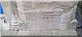
Ordnance Survey Cut Mark
This OS cut mark can be found on the SW face of Holy Trinity Church. It marks a point 94.509m above mean sea level.
Image: © Adrian Dust
Taken: 20 Sep 2018
0.04 miles
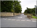
5
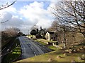
View from the bridge over Front Street at Pelton
This bridge carries the former railway path up towards Stanley. It affords a good view of Holy Trinity Church.
Image: © Robert Graham
Taken: 6 Feb 2013
0.04 miles
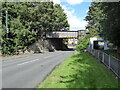
6
Disused railway bridge over Front Street, Pelton
Image: © JThomas
Taken: 2 May 2013
0.05 miles
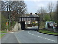
7
Pelton Bridge
Crossing Front Street, this substantial bridge once carried the Birtley, Annfield Plain and Consett railway but today is only used by walkers, cyclists and horse riders on the Consett and Sunderland Railway Path.
Image: © Adrian Taylor
Taken: 20 Aug 2020
0.05 miles
8
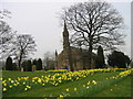
Holy Trinity Church, Pelton
Built from 1841-2 by G. Jackson.
Image: © Les Hull
Taken: 24 Apr 2006
0.06 miles
10
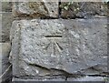
Benchmark, Pelton Bridge
Detail of the Ordnance Survey cut benchmark on the north east abutment of Pelton Bridge on the north side of Front Street. The benchmark marks a height of 83.579m above sea level (Ordnance Datum Newlyn) last verified in 1962.
Image: © Adrian Taylor
Taken: 20 Aug 2020
0.07 miles