IMAGES TAKEN NEAR TO
Ross, CHESTER LE STREET, DH2 1LD
Introduction
This page details the photographs taken nearby to Ross, DH2 1LD by members of the Geograph project.
The Geograph project started in 2005 with the aim of publishing, organising and preserving representative images for every square kilometre of Great Britain, Ireland and the Isle of Man.

There are currently over 7.5m images from over14,400 individuals and you can help contribute to the project by visiting https://www.geograph.org.uk
Image Map
Images are licensed for reuse under creativecommons.org/licenses/by-sa/2.0
Notes
- Clicking on the map will re-center to the selected point.
- The higher the marker number, the further away the image location is from the centre of the postcode.
Image Listing (5 Images Found)
Images are licensed for reuse under creativecommons.org/licenses/by-sa/2.0
Image
Details
Distance
3
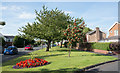
Grassed strip with flower bed and trees,
The garden strip divides the residential road, 'Cromarty' and the main road through Ouston; the view is to the north.
Image: © Trevor Littlewood
Taken: 30 Aug 2016
0.18 miles
5
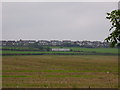
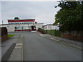
Scout Hut Ouston
The white building in the foreground is the scout hut with the Ross Park housing estate on behind it.
Image: © P Glenwright
Taken: 16 Sep 2006
0.22 miles