IMAGES TAKEN NEAR TO
Carnoustie, CHESTER LE STREET, DH2 1JS
Introduction
This page details the photographs taken nearby to Carnoustie, DH2 1JS by members of the Geograph project.
The Geograph project started in 2005 with the aim of publishing, organising and preserving representative images for every square kilometre of Great Britain, Ireland and the Isle of Man.

There are currently over 7.5m images from over14,400 individuals and you can help contribute to the project by visiting https://www.geograph.org.uk
Image Map
Images are licensed for reuse under creativecommons.org/licenses/by-sa/2.0
Notes
- Clicking on the map will re-center to the selected point.
- The higher the marker number, the further away the image location is from the centre of the postcode.
Image Listing (12 Images Found)
Images are licensed for reuse under creativecommons.org/licenses/by-sa/2.0
Image
Details
Distance
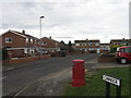
3
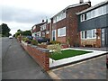
Houses on Millbanke Close
At the southern end of Ouston village.
Image: © Oliver Dixon
Taken: 11 Sep 2023
0.09 miles
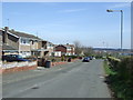
5
Houses on Millbanke Close
At the south-eastern corner of Ouston village. Seen from the road to Ouston Villa Farm.
Image: © Oliver Dixon
Taken: 11 Sep 2023
0.10 miles
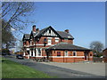
6
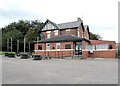
The Red Lion
Pub on the corner of Ouston Lane and Millbanke Close.
Image: © Oliver Dixon
Taken: 11 Sep 2023
0.11 miles
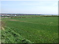
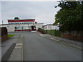
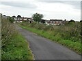
8
Wheat field beyond Milbanke Close
Milbanke Close is the road crossing beyond the tree. The view is from the edge of a modern housing estate in Ouston, at a corner of Byron Close.
Image: © Trevor Littlewood
Taken: 30 Aug 2016
0.11 miles