IMAGES TAKEN NEAR TO
High Flatts, CHESTER LE STREET, DH2 1BL
Introduction
This page details the photographs taken nearby to DH2 1BL by members of the Geograph project.
The Geograph project started in 2005 with the aim of publishing, organising and preserving representative images for every square kilometre of Great Britain, Ireland and the Isle of Man.

There are currently over 7.5m images from over14,400 individuals and you can help contribute to the project by visiting https://www.geograph.org.uk
Image Map
Images are licensed for reuse under creativecommons.org/licenses/by-sa/2.0
Notes
- Clicking on the map will re-center to the selected point.
- The higher the marker number, the further away the image location is from the centre of the postcode.
Image Listing (3 Images Found)
Images are licensed for reuse under creativecommons.org/licenses/by-sa/2.0
Image
Details
Distance
1
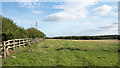
Field adjacent to Pelton Lane
Pelton Lane lies over the fence and hedge at the left side of the image.
Image: © Trevor Littlewood
Taken: 30 Aug 2016
0.04 miles
2
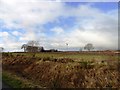
Looking across to High Flatts
View across the fields to High Flatts Farm from the old railway at South Pelaw.
Image: © Robert Graham
Taken: 6 Feb 2013
0.09 miles
3
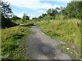
Footpath, Stella Gill Flatts
The public footpath from Stella Gill to High Flatts where it passes the site of the former Stella Gill Coke Works.
Image: © Adrian Taylor
Taken: 20 Aug 2020
0.24 miles